Ramat Yishay geodata
Ramat Yishay (Northern District) is a populated place; located in Israel in Asia/Jerusalem (GMT+3) time zone. With population of 5,431 people, there are 106 cities with bigger population in this country. Compared to other cities in Israel, 66.9% of cities are located further ↓South; 66.9% of cities are located further ←West and 51.5% of cities have higher elevation than Ramat Yishay. Note1


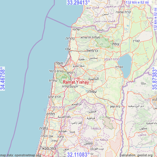
Ramat Yishay GPS coordinates[2]
32° 42' 15.984" North, 35° 10' 14.52" East
| Map corner | latitude | longitude |
|---|---|---|
| Upper-left | 33.29413°, | 34.46758° |
| Center: | 32.70444°, | 35.1707° |
| Lower-right: | 32.11083°, | 35.87383° |
| Map W x H: | 131.6×131.6 km | = 81.8×81.8mi |
| max Lat: | 33.27918° ⇑33.1% North |
| Ramat Yishay: | 32.70444° |
| min Lat: | ⇓66.9% South 29.55805° |
| min Long | Ramat Yishay | max Long |
| 34.57149° | 35.1707° | 35.81084° |
| W 66.9%⇐ | ⇒33.1% E |
Elevation
Elevation of Ramat Yishay is 98 m = 322 ft, and this is 125.4 m = 411 ft below average elevation for this country.
| Max E: |
988 m = 3241 ft | 51.5% |
| Avg. | 223.4 m = 733 ft | |
| Ramat Yishay | 98 m = 322 ft | |
Min E: |
-380 m = -1247 ft | 48.5% |
See also: Israel elevation on elevation.city.
Geographical zone
Ramat Yishay is located in North temperate zone (between Tropic of Cancer and the Arctic Circle). Distance of this Northern Tropic circle is 1030.5 km =640.3 mi to South.| Distance of | km | miles | from Ramat Yishay |
|---|---|---|---|
| North Pole | 6370.7 | 3958.6 | to North |
| Arctic Circle | 3764.8 | 2339.3 | to North |
| Tropic Cancer | 1030.5 | 640.3 | to South |
| Equator | 3636.4 | 2259.6 | to South |


Nearby cities:
15 places around Ramat Yishay: (largest is in red/bold)
• Basmat Ṭab‘ūn
4 km =2.5 mi,  341°
341°
• Bīr el Maksūr
9.4 km =5.8 mi,  29°
29°
• Daliyat al Karmel
11.6 km =7.2 mi,  264°
264°
• Er Reina
13.8 km =8.6 mi,  81°
81°
• Ibṭīn
8.3 km =5.2 mi,  320°
320°
• Iksāl
14.5 km =9 mi,  100°
100°
• Kafr Mandā
14.4 km =8.9 mi,  35°
35°
• Migdal Ha‘Emeq
7.2 km =4.5 mi,  116°
116°
• Nazareth
11.8 km =7.3 mi,  92°
92°
• Nesher
13.7 km =8.5 mi,  300°
300°
• Qiryat Ata
13.1 km =8.1 mi, 335°
• Rekhasim
8.3 km =5.2 mi,  306°
306°
• Rumat Heib
15 km =9.3 mi,  57°
57°
• Timrat
5 km =3.1 mi, 91°
• Ẕippori
11.2 km =7 mi,  66°
66°
Sources, notices
• [Note1] Compared only with cities in Israel existing in our database
• [Src1] Map data: © OpenStreetMap contributors (CC-BY-SA)
• [Src2] Other city data from geonames.org with taken over terms of usage.
• [Src3] Geographical zone / Annual Mean Temperature by Robert A. Rohde @ Wikipedia
