Ra'anana geodata
Ra'anana (Central District) is a populated place; located in Israel in Asia/Jerusalem (GMT+3) time zone. With population of 80,000 people, there are 19 cities with bigger population in this country. Compared to other cities in Israel, 52.1% of cities are located further ↑North; 77.5% of cities are located further →East and 73.4% of cities have higher elevation than Ra'anana. Note1


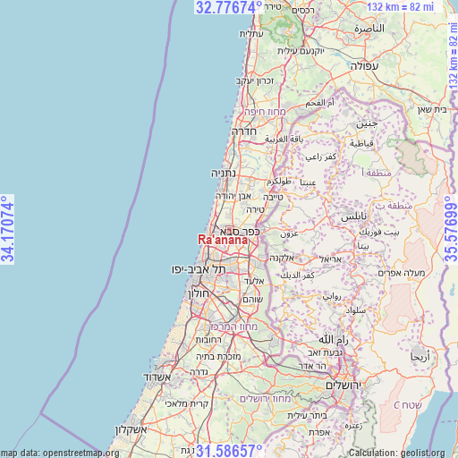
Ra'anana GPS coordinates[2]
32° 11' 0.96" North, 34° 52' 25.896" East
| Map corner | latitude | longitude |
|---|---|---|
| Upper-left | 32.77674°, | 34.17074° |
| Center: | 32.1836°, | 34.87386° |
| Lower-right: | 31.58657°, | 35.57699° |
| Map W x H: | 132.3×132.3 km | = 82.2×82.2mi |
| max Lat: | 33.27918° ⇑52.1% North |
| Ra'anana: | 32.1836° |
| min Lat: | ⇓47.9% South 29.55805° |
| min Long | Ra'anana | max Long |
| 34.57149° | 34.87386° | 35.81084° |
| W 22.5%⇐ | ⇒77.5% E |
Elevation
Elevation of Ra'anana is 49 m = 161 ft, and this is 174.4 m = 572 ft below average elevation for this country.
| Max E: |
988 m = 3241 ft | 73.4% |
| Avg. | 223.4 m = 733 ft | |
| Ra'anana | 49 m = 161 ft | |
Min E: |
-380 m = -1247 ft | 26.6% |
See also: Ra'anana elevation on elevation.city.
Geographical zone
Ra'anana is located in North temperate zone (between Tropic of Cancer and the Arctic Circle). Distance of this Northern Tropic circle is 972.6 km =604.3 mi to South.| Distance of | km | miles | from Ra'anana |
|---|---|---|---|
| North Pole | 6428.6 | 3994.5 | to North |
| Arctic Circle | 3822.7 | 2375.3 | to North |
| Tropic Cancer | 972.6 | 604.3 | to South |
| Equator | 3578.5 | 2223.6 | to South |


Nearby cities:
15 places around Ra'anana: (largest is in red/bold)
• Bnei Brak
12 km =7.5 mi,  198°
198°
• Even Yehuda
9.6 km =6 mi,  7°
7°
• Giv'at Shmuel
12 km =7.5 mi,  191°
191°
• Herzliya
5 km =3.1 mi,  247°
247°
• Herzliya Pituah
6.8 km =4.2 mi,  261°
261°
• Hod HaSharon
3.3 km =2.1 mi,  145°
145°
• Jaljūlya
8.2 km =5.1 mi,  113°
113°
• Kafr Qāsim
12.4 km =7.7 mi,  128°
128°
• Kefar Shemaryahu
5 km =3.1 mi,  272°
272°
• Kfar Saba
3.3 km =2.1 mi, 107°
• Nirit
11.3 km =7 mi, 111°
• Petaẖ Tiqwa
10.8 km =6.7 mi,  173°
173°
• Ramat HaSharon
5.3 km =3.3 mi,  217°
217°
• Tel Mond
8.4 km =5.2 mi,  29°
29°
• Tirah
9.1 km =5.7 mi,  51°
51°
Sources, notices
• [Note1] Compared only with cities in Israel existing in our database
• [Src1] Map data: © OpenStreetMap contributors (CC-BY-SA)
• [Src2] Other city data from geonames.org with taken over terms of usage.
• [Src3] Geographical zone / Annual Mean Temperature by Robert A. Rohde @ Wikipedia
