Ofaqim geodata
Ofaqim (Southern District) is a populated place; located in Israel in Asia/Jerusalem (GMT+3) time zone. With population of 24,311 people, there are 57 cities with bigger population in this country. Compared to other cities in Israel, 95.3% of cities are located further ↑North; 98.2% of cities are located further →East and 54.4% of cities have lower elevation than Ofaqim. Note1


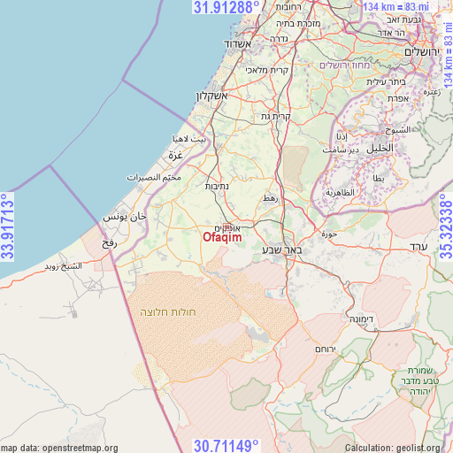
Ofaqim GPS coordinates[2]
31° 18' 50.76" North, 34° 37' 12.9" East
| Map corner | latitude | longitude |
|---|---|---|
| Upper-left | 31.91288°, | 33.91713° |
| Center: | 31.3141°, | 34.62025° |
| Lower-right: | 30.71149°, | 35.32338° |
| Map W x H: | 133.6×133.6 km | = 83×83mi |
| max Lat: | 33.27918° ⇑95.3% North |
| Ofaqim: | 31.3141° |
| min Lat: | ⇓4.7% South 29.55805° |
| min Long | Ofaqim | max Long |
| 34.57149° | 34.62025° | 35.81084° |
| W 1.8%⇐ | ⇒98.2% E |
Elevation
Elevation of Ofaqim is 137 m = 449 ft, and this is 86.4 m = 283 ft below average elevation for this country.
| Max E: |
988 m = 3241 ft | 45.6% |
| Avg. | 223.4 m = 733 ft | |
| Ofaqim | 137 m = 449 ft | |
Min E: |
-380 m = -1247 ft | 54.4% |
See also: Israel elevation on elevation.city.
Geographical zone
Ofaqim is located in North temperate zone (between Tropic of Cancer and the Arctic Circle). Distance of this Northern Tropic circle is 875.9 km =544.3 mi to South.| Distance of | km | miles | from Ofaqim |
|---|---|---|---|
| North Pole | 6525.3 | 4054.6 | to North |
| Arctic Circle | 3919.4 | 2435.4 | to North |
| Tropic Cancer | 875.9 | 544.3 | to South |
| Equator | 3481.8 | 2163.5 | to South |


Nearby cities:
15 places around Ofaqim: (largest is in red/bold)
• Arad
56.6 km =35.2 mi,  96°
96°
• Ashdod
53.2 km =33.1 mi,  3°
3°
• Ashkelon
39.8 km =24.7 mi,  353°
353°
• Beersheba
17.7 km =11 mi,  113°
113°
• Bnei Ayish
53.6 km =33.3 mi,  13°
13°
• Dimona
47.7 km =29.6 mi,  124°
124°
• Gan Yavne
53.3 km =33.1 mi, 8°
• Gedera
57.7 km =35.9 mi,  15°
15°
• Lehavim
19.7 km =12.2 mi,  70°
70°
• Midreshet Ben-Gurion
53.7 km =33.4 mi,  163°
163°
• Netivot
12.5 km =7.8 mi, 346°
• Qiryat Gat
35.6 km =22.1 mi, 22°
• Rahat
15.8 km =9.8 mi,  55°
55°
• Sederot
23.6 km =14.7 mi, 354°
• Yeroẖam
46.8 km =29.1 mi,  140°
140°
Sources, notices
• [Note1] Compared only with cities in Israel existing in our database
• [Src1] Map data: © OpenStreetMap contributors (CC-BY-SA)
• [Src2] Other city data from geonames.org with taken over terms of usage.
• [Src3] Geographical zone / Annual Mean Temperature by Robert A. Rohde @ Wikipedia
