Resubelpara geodata
Resubelpara (Meghalaya) is a seat of a second-order administrative division; located in India in Asia/Kolkata (GMT+5.5) time zone. In our database, there are 3475 cities with bigger population. Compared to other cities in India, 69.7% of cities are located further ↓South; 95.9% of cities are located further ←West and 74.2% of cities have higher elevation than Resubelpara. Note1


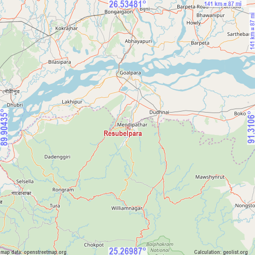
Resubelpara GPS coordinates[2]
25° 54' 14.544" North, 90° 36' 26.892" East
| Map corner | latitude | longitude |
|---|---|---|
| Upper-left | 26.53481°, | 89.90435° |
| Center: | 25.90404°, | 90.60747° |
| Lower-right: | 25.26987°, | 91.3106° |
| Map W x H: | 140.6×140.6 km | = 87.4×87.4mi |
| max Lat: | 34.9274° ⇑30.3% North |
| Resubelpara: | 25.90404° |
| min Lat: | ⇓69.7% South 8.09008° |
| min Long | Resubelpara | max Long |
| 68.82655° | 90.60747° | 96.81° |
| W 95.9%⇐ | ⇒4.1% E |
Elevation
Elevation of Resubelpara is 72 m = 236 ft, and this is 223.6 m = 734 ft below average elevation for this country.
| Max E: |
3681 m = 12077 ft | 74.2% |
| Avg. | 295.6 m = 970 ft | |
| Resubelpara | 72 m = 236 ft | |
Min E: |
1 m = 3 ft | 25.8% |
See also: India elevation on elevation.city.
Geographical zone
Resubelpara is located in North temperate zone (between Tropic of Cancer and the Arctic Circle). Distance of this Northern Tropic circle is 274.3 km =170.4 mi to South.| Distance of | km | miles | from Resubelpara |
|---|---|---|---|
| North Pole | 7126.8 | 4428.4 | to North |
| Arctic Circle | 4520.9 | 2809.2 | to North |
| Tropic Cancer | 274.3 | 170.4 | to South |
| Equator | 2880.3 | 1789.7 | to South |


Nearby cities:
15 places around Resubelpara: (largest is in red/bold)
• Abhayāpuri
47.2 km =29.3 mi,  9°
9°
• Barpeta
61.3 km =38.1 mi,  40°
40°
• Bijni
66.5 km =41.3 mi, 8°
• Bilāsipāra
52.2 km =32.4 mi,  314°
314°
• Bongaigaon
63.9 km =39.7 mi,  355°
355°
• Bāsugaon
65.4 km =40.6 mi,  343°
343°
• Chāpar
44.1 km =27.4 mi, 338°
• Dhuburi
63.5 km =39.5 mi,  281°
281°
• Gauripur
67.6 km =42 mi,  287°
287°
• Goālpāra
30.4 km =18.9 mi,  3°
3°
• Jogīghopa
36 km =22.4 mi,  354°
354°
• Kokrajhar
64.6 km =40.1 mi,  328°
328°
• Lakhipur
33.2 km =20.6 mi, 294°
• Tura
59.4 km =36.9 mi,  223°
223°
• Williamnagar
45.4 km =28.2 mi,  178°
178°
Sources, notices
• [Note1] Compared only with cities in India existing in our database
• [Src1] Map data: © OpenStreetMap contributors (CC-BY-SA)
• [Src2] Other city data from geonames.org with taken over terms of usage.
• [Src3] Geographical zone / Annual Mean Temperature by Robert A. Rohde @ Wikipedia
