Jogīghopa geodata
Jogīghopa (Assam) is a populated place; located in India in Asia/Kolkata (GMT+5.5) time zone. With population of 2,415 people, there are 3428 cities with bigger population in this country. Compared to other cities in India, 72.2% of cities are located further ↓South; 95.9% of cities are located further ←West and 82.1% of cities have higher elevation than Jogīghopa. Note1


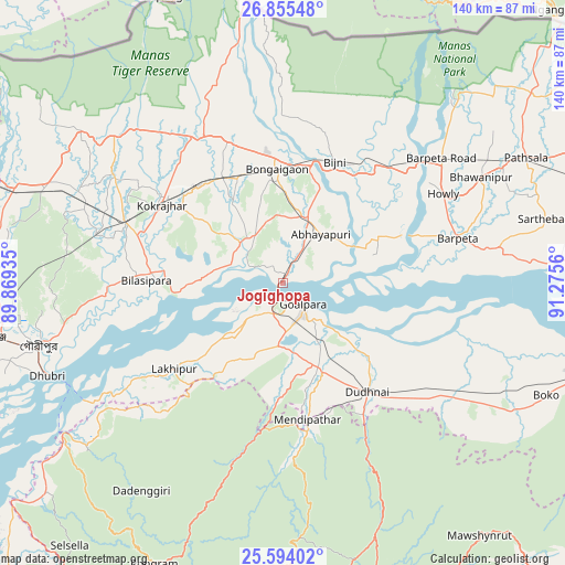
Jogīghopa GPS coordinates[2]
26° 13' 35.256" North, 90° 34' 20.892" East
| Map corner | latitude | longitude |
|---|---|---|
| Upper-left | 26.85548°, | 89.86935° |
| Center: | 26.22646°, | 90.57247° |
| Lower-right: | 25.59402°, | 91.2756° |
| Map W x H: | 140.3×140.3 km | = 87.2×87.2mi |
| max Lat: | 34.9274° ⇑27.8% North |
| Jogīghopa: | 26.22646° |
| min Lat: | ⇓72.2% South 8.09008° |
| min Long | Jogīghopa | max Long |
| 68.82655° | 90.57247° | 96.81° |
| W 95.9%⇐ | ⇒4.1% E |
Elevation
Elevation of Jogīghopa is 40 m = 131 ft, and this is 255.6 m = 839 ft below average elevation for this country.
| Max E: |
3681 m = 12077 ft | 82.1% |
| Avg. | 295.6 m = 970 ft | |
| Jogīghopa | 40 m = 131 ft | |
Min E: |
1 m = 3 ft | 17.9% |
See also: India elevation on elevation.city.
Geographical zone
Jogīghopa is located in North temperate zone (between Tropic of Cancer and the Arctic Circle). Distance of this Northern Tropic circle is 310.2 km =192.7 mi to South.| Distance of | km | miles | from Jogīghopa |
|---|---|---|---|
| North Pole | 7091 | 4406.1 | to North |
| Arctic Circle | 4485.1 | 2786.9 | to North |
| Tropic Cancer | 310.2 | 192.7 | to South |
| Equator | 2916.1 | 1812 | to South |


Nearby cities:
15 places around Jogīghopa: (largest is in red/bold)
• Abhayāpuri
15.5 km =9.6 mi,  46°
46°
• Barpeta
44.6 km =27.7 mi,  76°
76°
• Barpeta Road
50.1 km =31.1 mi, 52°
• Bijni
32.7 km =20.3 mi,  23°
23°
• Bilāsipāra
33.8 km =21 mi,  271°
271°
• Bongaigaon
27.9 km =17.3 mi,  357°
357°
• Bāsugaon
30.8 km =19.1 mi,  330°
330°
• Chāpar
13.7 km =8.5 mi,  292°
292°
• Goālpāra
7.7 km =4.8 mi,  135°
135°
• Howli
46.1 km =28.6 mi,  61°
61°
• Kokrajhar
35.6 km =22.1 mi,  303°
303°
• Lakhipur
34.4 km =21.4 mi,  230°
230°
• Resubelpara
36 km =22.4 mi,  174°
174°
• Sapatgrām
46.4 km =28.8 mi, 285°
• Sorbhog
42.5 km =26.4 mi, 47°
Sources, notices
• [Note1] Compared only with cities in India existing in our database
• [Src1] Map data: © OpenStreetMap contributors (CC-BY-SA)
• [Src2] Other city data from geonames.org with taken over terms of usage.
• [Src3] Geographical zone / Annual Mean Temperature by Robert A. Rohde @ Wikipedia
