Bijni geodata
Bijni (Assam) is a populated place; located in India in Asia/Kolkata (GMT+5.5) time zone. With population of 12,990 people, there are 2656 cities with bigger population in this country. Compared to other cities in India, 74.6% of cities are located further ↓South; 96% of cities are located further ←West and 78.3% of cities have higher elevation than Bijni. Note1


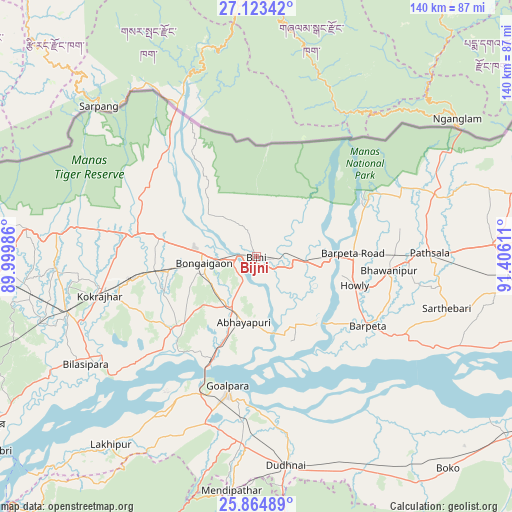
Bijni GPS coordinates[2]
26° 29' 45.168" North, 90° 42' 10.728" East
| Map corner | latitude | longitude |
|---|---|---|
| Upper-left | 27.12342°, | 89.99986° |
| Center: | 26.49588°, | 90.70298° |
| Lower-right: | 25.86489°, | 91.40611° |
| Map W x H: | 139.9×139.9 km | = 86.9×86.9mi |
| max Lat: | 34.9274° ⇑25.4% North |
| Bijni: | 26.49588° |
| min Lat: | ⇓74.6% South 8.09008° |
| min Long | Bijni | max Long |
| 68.82655° | 90.70298° | 96.81° |
| W 96%⇐ | ⇒4% E |
Elevation
Elevation of Bijni is 54 m = 177 ft, and this is 241.6 m = 793 ft below average elevation for this country.
| Max E: |
3681 m = 12077 ft | 78.3% |
| Avg. | 295.6 m = 970 ft | |
| Bijni | 54 m = 177 ft | |
Min E: |
1 m = 3 ft | 21.7% |
See also: India elevation on elevation.city.
Geographical zone
Bijni is located in North temperate zone (between Tropic of Cancer and the Arctic Circle). Distance of this Northern Tropic circle is 340.1 km =211.3 mi to South.| Distance of | km | miles | from Bijni |
|---|---|---|---|
| North Pole | 7061 | 4387.5 | to North |
| Arctic Circle | 4455.1 | 2768.3 | to North |
| Tropic Cancer | 340.1 | 211.3 | to South |
| Equator | 2946.1 | 1830.6 | to South |


Nearby cities:
15 places around Bijni: (largest is in red/bold)
• Abhayāpuri
19.4 km =12.1 mi,  185°
185°
• Barpeta
35.8 km =22.2 mi,  122°
122°
• Barpeta Road
26.5 km =16.5 mi,  88°
88°
• Bilāsipāra
55.1 km =34.2 mi,  237°
237°
• Bongaigaon
14.6 km =9.1 mi,  261°
261°
• Bāsugaon
28.4 km =17.6 mi, 263°
• Chāpar
35.7 km =22.2 mi,  225°
225°
• Goālpāra
36.3 km =22.6 mi, 192°
• Howli
28.8 km =17.9 mi,  106°
106°
• Jogīghopa
32.7 km =20.3 mi,  203°
203°
• Kokrajhar
44.1 km =27.4 mi, 256°
• Lakhipur
65.2 km =40.5 mi,  217°
217°
• Resubelpara
66.5 km =41.3 mi, 188°
• Sapatgrām
60.3 km =37.5 mi,  253°
253°
• Sorbhog
18.2 km =11.3 mi, 93°
Sources, notices
• [Note1] Compared only with cities in India existing in our database
• [Src1] Map data: © OpenStreetMap contributors (CC-BY-SA)
• [Src2] Other city data from geonames.org with taken over terms of usage.
• [Src3] Geographical zone / Annual Mean Temperature by Robert A. Rohde @ Wikipedia
