Dhuburi geodata
Dhuburi (Assam) is a populated place; located in India in Asia/Kolkata (GMT+5.5) time zone. With population of 62,525 people, there are 703 cities with bigger population in this country. Compared to other cities in India, 70.4% of cities are located further ↓South; 95.6% of cities are located further ←West and 83.9% of cities have higher elevation than Dhuburi. Note1


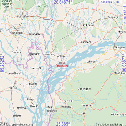
Dhuburi GPS coordinates[2]
26° 1' 6.816" North, 89° 59' 8.304" East
| Map corner | latitude | longitude |
|---|---|---|
| Upper-left | 26.64871°, | 89.28252° |
| Center: | 26.01856°, | 89.98564° |
| Lower-right: | 25.385°, | 90.68877° |
| Map W x H: | 140.5×140.5 km | = 87.3×87.3mi |
| max Lat: | 34.9274° ⇑29.6% North |
| Dhuburi: | 26.01856° |
| min Lat: | ⇓70.4% South 8.09008° |
| min Long | Dhuburi | max Long |
| 68.82655° | 89.98564° | 96.81° |
| W 95.6%⇐ | ⇒4.4% E |
Elevation
Elevation of Dhuburi is 34 m = 112 ft, and this is 261.6 m = 858 ft below average elevation for this country.
| Max E: |
3681 m = 12077 ft | 83.9% |
| Avg. | 295.6 m = 970 ft | |
| Dhuburi | 34 m = 112 ft | |
Min E: |
1 m = 3 ft | 16.1% |
See also: Dhuburi elevation on elevation.city.
Geographical zone
Dhuburi is located in North temperate zone (between Tropic of Cancer and the Arctic Circle). Distance of this Northern Tropic circle is 287.1 km =178.4 mi to South.| Distance of | km | miles | from Dhuburi |
|---|---|---|---|
| North Pole | 7114.1 | 4420.5 | to North |
| Arctic Circle | 4508.2 | 2801.3 | to North |
| Tropic Cancer | 287.1 | 178.4 | to South |
| Equator | 2893 | 1797.6 | to South |


Nearby cities:
15 places around Dhuburi: (largest is in red/bold)
• Ampati
62.1 km =38.6 mi,  184°
184°
• Bilāsipāra
34.4 km =21.4 mi,  46°
46°
• Chāpar
53.9 km =33.5 mi,  58°
58°
• Dīnhāta
54 km =33.6 mi,  283°
283°
• Gauripur
7.6 km =4.7 mi,  341°
341°
• Golakganj
18.7 km =11.6 mi,  299°
299°
• Goshaingaon
46.9 km =29.1 mi,  357°
357°
• Hatsingimari
35.4 km =22 mi,  193°
193°
• Kokrajhar
51.3 km =31.9 mi,  33°
33°
• Lakhipur
32 km =19.9 mi,  87°
87°
• Latabāri
34.4 km =21.4 mi, 338°
• Mankāchar
55.3 km =34.4 mi, 192°
• Sapatgrām
38 km =23.6 mi,  21°
21°
• Tufānganj
46.1 km =28.6 mi,  316°
316°
• Tura
60.1 km =37.3 mi,  158°
158°
Sources, notices
• [Note1] Compared only with cities in India existing in our database
• [Src1] Map data: © OpenStreetMap contributors (CC-BY-SA)
• [Src2] Other city data from geonames.org with taken over terms of usage.
• [Src3] Geographical zone / Annual Mean Temperature by Robert A. Rohde @ Wikipedia
