Boisar geodata
Boisar (Maharashtra) is a populated place; located in India in Asia/Kolkata (GMT+5.5) time zone. With population of 15,692 people, there are 2399 cities with bigger population in this country. Compared to other cities in India, 65.9% of cities are located further ↑North; 96.1% of cities are located further →East and 91.1% of cities have higher elevation than Boisar. Note1


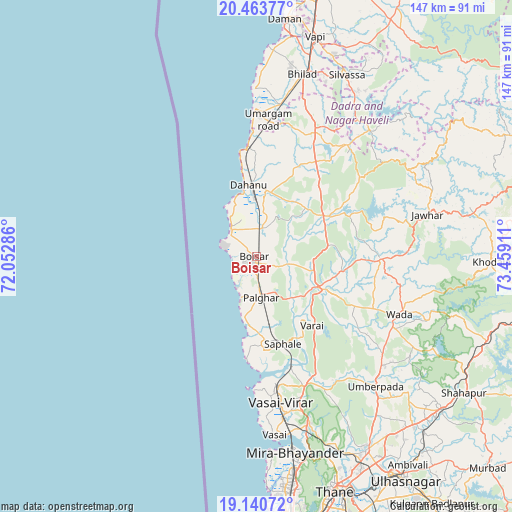
Boisar GPS coordinates[2]
19° 48' 13.032" North, 72° 45' 21.528" East
| Map corner | latitude | longitude |
|---|---|---|
| Upper-left | 20.46377°, | 72.05286° |
| Center: | 19.80362°, | 72.75598° |
| Lower-right: | 19.14072°, | 73.45911° |
| Map W x H: | 147.1×147.1 km | = 91.4×91.4mi |
| max Lat: | 34.9274° ⇑65.9% North |
| Boisar: | 19.80362° |
| min Lat: | ⇓34.1% South 8.09008° |
| min Long | Boisar | max Long |
| 68.82655° | 72.75598° | 96.81° |
| W 3.9%⇐ | ⇒96.1% E |
Elevation
Elevation of Boisar is 16 m = 52 ft, and this is 279.6 m = 917 ft below average elevation for this country.
| Max E: |
3681 m = 12077 ft | 91.1% |
| Avg. | 295.6 m = 970 ft | |
| Boisar | 16 m = 52 ft | |
Min E: |
1 m = 3 ft | 8.9% |
See also: India elevation on elevation.city.
Geographical zone
Boisar is located in North Torrid zone (between Equator and Tropic of Cancer). Distance of this Northern Tropic circle is 404 km =251 mi to North.| Distance of | km | miles | from Boisar |
|---|---|---|---|
| North Pole | 7805.1 | 4849.9 | to North |
| Arctic Circle | 5199.2 | 3230.6 | to North |
| Tropic Cancer | 404 | 251 | to North |
| Equator | 2202 | 1368.3 | to South |


Nearby cities:
15 places around Boisar: (largest is in red/bold)
• Bhayandar
56.7 km =35.2 mi,  169°
169°
• Bhiwandi
64.3 km =40 mi,  150°
150°
• Borivli
64.2 km =39.9 mi, 170°
• Chinchani
10.8 km =6.7 mi,  316°
316°
• Dadra
62 km =38.5 mi,  20°
20°
• Dāhānu
18.8 km =11.7 mi,  346°
346°
• Jawhār
50.7 km =31.5 mi,  76°
76°
• Manor
18.3 km =11.4 mi,  118°
118°
• Pālghar
11.9 km =7.4 mi,  175°
175°
• Shirgaon
12.7 km =7.9 mi,  199°
199°
• Silvassa
58 km =36 mi,  25°
25°
• Tārāpur
10.1 km =6.3 mi,  312°
312°
• Virār
39.1 km =24.3 mi, 171°
• Vāda
44.3 km =27.5 mi,  112°
112°
• Āmli
59.9 km =37.2 mi, 27°
Sources, notices
• [Note1] Compared only with cities in India existing in our database
• [Src1] Map data: © OpenStreetMap contributors (CC-BY-SA)
• [Src2] Other city data from geonames.org with taken over terms of usage.
• [Src3] Geographical zone / Annual Mean Temperature by Robert A. Rohde @ Wikipedia
