Manor geodata
Manor (Maharashtra) is a populated place; located in India in Asia/Kolkata (GMT+5.5) time zone. With population of 8,918 people, there are 3042 cities with bigger population in this country. Compared to other cities in India, 66.2% of cities are located further ↑North; 95.3% of cities are located further →East and 89.3% of cities have higher elevation than Manor. Note1


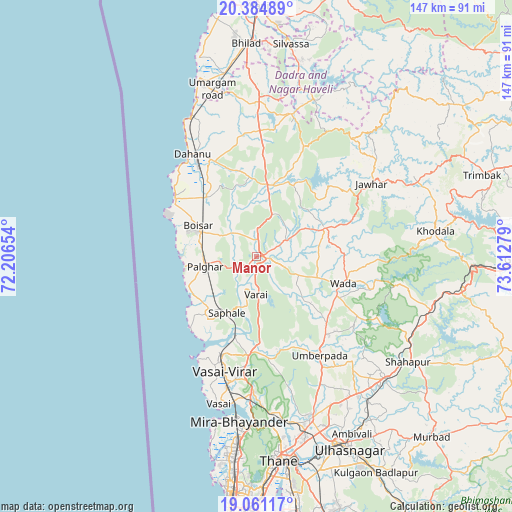
Manor GPS coordinates[2]
19° 43' 27.84" North, 72° 54' 34.776" East
| Map corner | latitude | longitude |
|---|---|---|
| Upper-left | 20.38489°, | 72.20654° |
| Center: | 19.7244°, | 72.90966° |
| Lower-right: | 19.06117°, | 73.61279° |
| Map W x H: | 147.2×147.2 km | = 91.5×91.5mi |
| max Lat: | 34.9274° ⇑66.2% North |
| Manor: | 19.7244° |
| min Lat: | ⇓33.8% South 8.09008° |
| min Long | Manor | max Long |
| 68.82655° | 72.90966° | 96.81° |
| W 4.7%⇐ | ⇒95.3% E |
Elevation
Elevation of Manor is 19 m = 62 ft, and this is 276.6 m = 907 ft below average elevation for this country.
| Max E: |
3681 m = 12077 ft | 89.3% |
| Avg. | 295.6 m = 970 ft | |
| Manor | 19 m = 62 ft | |
Min E: |
1 m = 3 ft | 10.7% |
See also: India elevation on elevation.city.
Geographical zone
Manor is located in North Torrid zone (between Equator and Tropic of Cancer). Distance of this Northern Tropic circle is 412.8 km =256.5 mi to North.| Distance of | km | miles | from Manor |
|---|---|---|---|
| North Pole | 7813.9 | 4855.3 | to North |
| Arctic Circle | 5208 | 3236.1 | to North |
| Tropic Cancer | 412.8 | 256.5 | to North |
| Equator | 2193.1 | 1362.7 | to South |


Nearby cities:
15 places around Manor: (largest is in red/bold)
• Bhayandar
47.4 km =29.5 mi,  187°
187°
• Bhiwandi
49.7 km =30.9 mi,  161°
161°
• Boisar
18.3 km =11.4 mi,  298°
298°
• Borivli
54.7 km =34 mi, 185°
• Chinchani
28.8 km =17.9 mi,  305°
305°
• Dāhānu
34 km =21.1 mi,  322°
322°
• Jawhār
39.2 km =24.4 mi,  57°
57°
• Kalyān
58.5 km =36.4 mi, 156°
• Pālghar
15.4 km =9.6 mi,  258°
258°
• Shirgaon
20.6 km =12.8 mi, 261°
• Shāhāpur
53.1 km =33 mi,  124°
124°
• Tārāpur
28.3 km =17.6 mi, 303°
• Vasind
51 km =31.7 mi,  133°
133°
• Virār
31.6 km =19.6 mi,  199°
199°
• Vāda
26.2 km =16.3 mi,  107°
107°
Sources, notices
• [Note1] Compared only with cities in India existing in our database
• [Src1] Map data: © OpenStreetMap contributors (CC-BY-SA)
• [Src2] Other city data from geonames.org with taken over terms of usage.
• [Src3] Geographical zone / Annual Mean Temperature by Robert A. Rohde @ Wikipedia
