Pālghar geodata
Pālghar (Maharashtra) is a seat of a second-order administrative division; located in India in Asia/Kolkata (GMT+5.5) time zone. With population of 72,335 people, there are 605 cities with bigger population in this country. Compared to other cities in India, 66.3% of cities are located further ↑North; 96% of cities are located further →East and 90.4% of cities have higher elevation than Pālghar. Note1


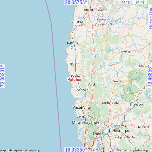
Pālghar GPS coordinates[2]
19° 41' 48.948" North, 72° 45' 55.548" East
| Map corner | latitude | longitude |
|---|---|---|
| Upper-left | 20.35753°, | 72.06231° |
| Center: | 19.69693°, | 72.76543° |
| Lower-right: | 19.03359°, | 73.46856° |
| Map W x H: | 147.2×147.2 km | = 91.5×91.5mi |
| max Lat: | 34.9274° ⇑66.3% North |
| Pālghar: | 19.69693° |
| min Lat: | ⇓33.7% South 8.09008° |
| min Long | Pālghar | max Long |
| 68.82655° | 72.76543° | 96.81° |
| W 4%⇐ | ⇒96% E |
Elevation
Elevation of Pālghar is 17 m = 56 ft, and this is 278.6 m = 914 ft below average elevation for this country.
| Max E: |
3681 m = 12077 ft | 90.4% |
| Avg. | 295.6 m = 970 ft | |
| Pālghar | 17 m = 56 ft | |
Min E: |
1 m = 3 ft | 9.6% |
See also: Pālghar elevation on elevation.city.
Geographical zone
Pālghar is located in North Torrid zone (between Equator and Tropic of Cancer). Distance of this Northern Tropic circle is 415.8 km =258.4 mi to North.| Distance of | km | miles | from Pālghar |
|---|---|---|---|
| North Pole | 7817 | 4857.3 | to North |
| Arctic Circle | 5211.1 | 3238 | to North |
| Tropic Cancer | 415.8 | 258.4 | to North |
| Equator | 2190.1 | 1360.9 | to South |


Nearby cities:
15 places around Pālghar: (largest is in red/bold)
• Bhayandar
44.9 km =27.9 mi,  168°
168°
• Bhiwandi
53.8 km =33.4 mi,  145°
145°
• Boisar
11.9 km =7.4 mi,  355°
355°
• Borivli
52.3 km =32.5 mi, 169°
• Chinchani
21.5 km =13.4 mi,  336°
336°
• Dombivli
62.9 km =39.1 mi, 148°
• Dāhānu
30.6 km =19 mi,  349°
349°
• Jawhār
53.9 km =33.5 mi,  63°
63°
• Manor
15.4 km =9.6 mi,  78°
78°
• Shirgaon
5.3 km =3.3 mi,  268°
268°
• Thāne
59.3 km =36.8 mi,  159°
159°
• Tārāpur
20.5 km =12.7 mi, 335°
• Vasind
61.2 km =38 mi,  121°
121°
• Virār
27.2 km =16.9 mi, 169°
• Vāda
40.4 km =25.1 mi,  96°
96°
Sources, notices
• [Note1] Compared only with cities in India existing in our database
• [Src1] Map data: © OpenStreetMap contributors (CC-BY-SA)
• [Src2] Other city data from geonames.org with taken over terms of usage.
• [Src3] Geographical zone / Annual Mean Temperature by Robert A. Rohde @ Wikipedia
