Changanācheri geodata
Changanācheri (Kerala) is a populated place; located in India in Asia/Kolkata (GMT+5.5) time zone. With population of 51,430 people, there are 869 cities with bigger population in this country. Compared to other cities in India, 97.9% of cities are located further ↑North; 68% of cities are located further →East and 92.8% of cities have higher elevation than Changanācheri. Note1


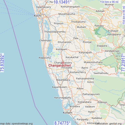
Changanācheri GPS coordinates[2]
9° 26' 31.308" North, 76° 32' 9.744" East
| Map corner | latitude | longitude |
|---|---|---|
| Upper-left | 10.13491°, | 75.83292° |
| Center: | 9.44203°, | 76.53604° |
| Lower-right: | 8.74775°, | 77.23917° |
| Map W x H: | 154.2×154.2 km | = 95.8×95.8mi |
| max Lat: | 34.9274° ⇑97.9% North |
| Changanācheri: | 9.44203° |
| min Lat: | ⇓2.1% South 8.09008° |
| min Long | Changanācheri | max Long |
| 68.82655° | 76.53604° | 96.81° |
| W 32%⇐ | ⇒68% E |
Elevation
Elevation of Changanācheri is 14 m = 46 ft, and this is 281.6 m = 924 ft below average elevation for this country.
| Max E: |
3681 m = 12077 ft | 92.8% |
| Avg. | 295.6 m = 970 ft | |
| Changanācheri | 14 m = 46 ft | |
Min E: |
1 m = 3 ft | 7.2% |
See also: Changanācheri elevation on elevation.city.
Geographical zone
Changanācheri is located in North Torrid zone (between Equator and Tropic of Cancer). Distance of Equator is 1049.9 km =652.4 mi to South.| Distance of | km | miles | from Changanācheri |
|---|---|---|---|
| North Pole | 8957.2 | 5565.7 | to North |
| Arctic Circle | 6351.3 | 3946.5 | to North |
| Tropic Cancer | 1556.1 | 966.9 | to North |
| Equator | 1049.9 | 652.4 | to South |


Nearby cities:
15 places around Changanācheri: (largest is in red/bold)
• Alappuzha
23.6 km =14.7 mi,  283°
283°
• Chengannūr
16.5 km =10.3 mi,  148°
148°
• Cherthala
34.8 km =21.6 mi,  320°
320°
• Kalavoor
27 km =16.8 mi,  301°
301°
• Kattanam
29.7 km =18.5 mi,  174°
174°
• Kottayam
16.2 km =10.1 mi,  354°
354°
• Kunnumma
16.5 km =10.3 mi,  234°
234°
• Kāyankulam
29.2 km =18.1 mi,  187°
187°
• Lālam
35.4 km =22 mi,  30°
30°
• Māvelikara
20.4 km =12.7 mi, 173°
• Palackattumala
35.1 km =21.8 mi,  16°
16°
• Pathanāmthitta
33.4 km =20.8 mi,  125°
125°
• Shertallai
34.6 km =21.5 mi, 321°
• Tiruvalla
8 km =5 mi, 147°
• Vayalār
37 km =23 mi, 324°
Sources, notices
• [Note1] Compared only with cities in India existing in our database
• [Src1] Map data: © OpenStreetMap contributors (CC-BY-SA)
• [Src2] Other city data from geonames.org with taken over terms of usage.
• [Src3] Geographical zone / Annual Mean Temperature by Robert A. Rohde @ Wikipedia
