Tirur geodata
Tirur (Kerala) is a populated place; located in India in Asia/Kolkata (GMT+5.5) time zone. With population of 54,934 people, there are 811 cities with bigger population in this country. Compared to other cities in India, 93.6% of cities are located further ↑North; 74.4% of cities are located further →East and 91.9% of cities have higher elevation than Tirur. Note1


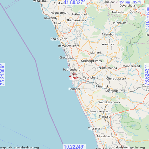
Tirur GPS coordinates[2]
10° 54' 49.248" North, 75° 55' 16.248" East
| Map corner | latitude | longitude |
|---|---|---|
| Upper-left | 11.60327°, | 75.21806° |
| Center: | 10.91368°, | 75.92118° |
| Lower-right: | 10.22249°, | 76.62431° |
| Map W x H: | 153.5×153.5 km | = 95.4×95.4mi |
| max Lat: | 34.9274° ⇑93.6% North |
| Tirur: | 10.91368° |
| min Lat: | ⇓6.4% South 8.09008° |
| min Long | Tirur | max Long |
| 68.82655° | 75.92118° | 96.81° |
| W 25.6%⇐ | ⇒74.4% E |
Elevation
Elevation of Tirur is 15 m = 49 ft, and this is 280.6 m = 921 ft below average elevation for this country.
| Max E: |
3681 m = 12077 ft | 91.9% |
| Avg. | 295.6 m = 970 ft | |
| Tirur | 15 m = 49 ft | |
Min E: |
1 m = 3 ft | 8.1% |
See also: Tirur elevation on elevation.city.
Geographical zone
Tirur is located in North Torrid zone (between Equator and Tropic of Cancer). Distance of Equator is 1213.5 km =754 mi to South.| Distance of | km | miles | from Tirur |
|---|---|---|---|
| North Pole | 8793.6 | 5464.1 | to North |
| Arctic Circle | 6187.7 | 3844.9 | to North |
| Tropic Cancer | 1392.4 | 865.2 | to North |
| Equator | 1213.5 | 754 | to South |


Nearby cities:
15 places around Tirur: (largest is in red/bold)
• Avanoor
43.9 km =27.3 mi,  140°
140°
• Beypore
31.3 km =19.4 mi,  336°
336°
• Cherpulassery
42.6 km =26.5 mi,  95°
95°
• Edakkulam
44.3 km =27.5 mi, 139°
• Ferokh
30.9 km =19.2 mi, 343°
• Guruvāyūr
37.9 km =23.5 mi,  159°
159°
• Kozhikode
40.2 km =25 mi, 337°
• Kunnamangalam
43.7 km =27.2 mi,  353°
353°
• Kunnamkulam
33.7 km =20.9 mi,  151°
151°
• Malappuram
22.6 km =14 mi,  50°
50°
• Manjeri
31.6 km =19.6 mi,  43°
43°
• Mavoor
39.3 km =24.4 mi,  359°
359°
• Pariyāpuram
12.9 km =8 mi,  332°
332°
• Ponnāni
16.3 km =10.1 mi,  178°
178°
• Shōranūr
41.7 km =25.9 mi,  113°
113°
Sources, notices
• [Note1] Compared only with cities in India existing in our database
• [Src1] Map data: © OpenStreetMap contributors (CC-BY-SA)
• [Src2] Other city data from geonames.org with taken over terms of usage.
• [Src3] Geographical zone / Annual Mean Temperature by Robert A. Rohde @ Wikipedia
