Beypore geodata
Beypore (Kerala) is a populated place; located in India in Asia/Kolkata (GMT+5.5) time zone. With population of 70,751 people, there are 617 cities with bigger population in this country. Compared to other cities in India, 92.5% of cities are located further ↑North; 75.6% of cities are located further →East and 91.9% of cities have higher elevation than Beypore. Note1


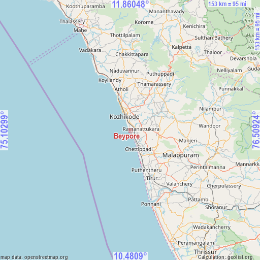
Beypore GPS coordinates[2]
11° 10' 17.436" North, 75° 48' 21.996" East
| Map corner | latitude | longitude |
|---|---|---|
| Upper-left | 11.86048°, | 75.10299° |
| Center: | 11.17151°, | 75.80611° |
| Lower-right: | 10.4809°, | 76.50924° |
| Map W x H: | 153.4×153.4 km | = 95.3×95.3mi |
| max Lat: | 34.9274° ⇑92.5% North |
| Beypore: | 11.17151° |
| min Lat: | ⇓7.5% South 8.09008° |
| min Long | Beypore | max Long |
| 68.82655° | 75.80611° | 96.81° |
| W 24.4%⇐ | ⇒75.6% E |
Elevation
Elevation of Beypore is 15 m = 49 ft, and this is 280.6 m = 921 ft below average elevation for this country.
| Max E: |
3681 m = 12077 ft | 91.9% |
| Avg. | 295.6 m = 970 ft | |
| Beypore | 15 m = 49 ft | |
Min E: |
1 m = 3 ft | 8.1% |
See also: Beypore elevation on elevation.city.
Geographical zone
Beypore is located in North Torrid zone (between Equator and Tropic of Cancer). Distance of Equator is 1242.2 km =771.9 mi to South.| Distance of | km | miles | from Beypore |
|---|---|---|---|
| North Pole | 8764.9 | 5446.3 | to North |
| Arctic Circle | 6159 | 3827 | to North |
| Tropic Cancer | 1363.8 | 847.4 | to North |
| Equator | 1242.2 | 771.9 | to South |


Nearby cities:
15 places around Beypore: (largest is in red/bold)
• Badagara
53.3 km =33.1 mi,  332°
332°
• Cherpulassery
64 km =39.8 mi,  120°
120°
• Ferokh
4 km =2.5 mi,  76°
76°
• Iringal
47.8 km =29.7 mi, 334°
• Kalpatta
57.2 km =35.5 mi,  31°
31°
• Kozhikode
9 km =5.6 mi,  341°
341°
• Kunnamangalam
16.7 km =10.4 mi, 27°
• Malappuram
33.3 km =20.7 mi, 115°
• Manjeri
34.7 km =21.6 mi,  99°
99°
• Mavoor
16 km =9.9 mi,  48°
48°
• Naduvannūr
35.3 km =21.9 mi,  354°
354°
• Nādāpuram
59.4 km =36.9 mi, 343°
• Pariyāpuram
18.4 km =11.4 mi,  159°
159°
• Ponnāni
46.8 km =29.1 mi, 163°
• Tirur
31.3 km =19.4 mi, 156°
Sources, notices
• [Note1] Compared only with cities in India existing in our database
• [Src1] Map data: © OpenStreetMap contributors (CC-BY-SA)
• [Src2] Other city data from geonames.org with taken over terms of usage.
• [Src3] Geographical zone / Annual Mean Temperature by Robert A. Rohde @ Wikipedia
