Avanoor geodata
Avanoor (Kerala) is a populated locality; located in India in Asia/Kolkata (GMT+5.5) time zone. With population of 5,000 people, there are 3343 cities with bigger population in this country. Compared to other cities in India, 94.6% of cities are located further ↑North; 72% of cities are located further →East and 91.1% of cities have higher elevation than Avanoor. Note1


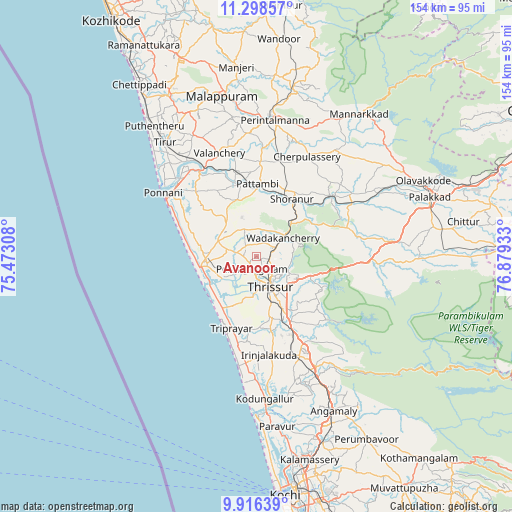
Avanoor GPS coordinates[2]
10° 36' 29.736" North, 76° 10' 34.32" East
| Map corner | latitude | longitude |
|---|---|---|
| Upper-left | 11.29857°, | 75.47308° |
| Center: | 10.60826°, | 76.1762° |
| Lower-right: | 9.91639°, | 76.87933° |
| Map W x H: | 153.7×153.7 km | = 95.5×95.5mi |
| max Lat: | 34.9274° ⇑94.6% North |
| Avanoor: | 10.60826° |
| min Lat: | ⇓5.4% South 8.09008° |
| min Long | Avanoor | max Long |
| 68.82655° | 76.1762° | 96.81° |
| W 28%⇐ | ⇒72% E |
Elevation
Elevation of Avanoor is 16 m = 52 ft, and this is 279.6 m = 917 ft below average elevation for this country.
| Max E: |
3681 m = 12077 ft | 91.1% |
| Avg. | 295.6 m = 970 ft | |
| Avanoor | 16 m = 52 ft | |
Min E: |
1 m = 3 ft | 8.9% |
See also: India elevation on elevation.city.
Geographical zone
Avanoor is located in North Torrid zone (between Equator and Tropic of Cancer). Distance of Equator is 1179.5 km =732.9 mi to South.| Distance of | km | miles | from Avanoor |
|---|---|---|---|
| North Pole | 8827.5 | 5485.2 | to North |
| Arctic Circle | 6221.6 | 3865.9 | to North |
| Tropic Cancer | 1426.4 | 886.3 | to North |
| Equator | 1179.5 | 732.9 | to South |


Nearby cities:
15 places around Avanoor: (largest is in red/bold)
• Cherpulassery
33.2 km =20.6 mi,  25°
25°
• Chetwayi
16.6 km =10.3 mi,  237°
237°
• Chēlakara
20.6 km =12.8 mi,  62°
62°
• Edakkulam
0.8 km =0.5 mi,  74°
74°
• Guruvāyūr
14.8 km =9.2 mi,  263°
263°
• Irinjālakuda
29.8 km =18.5 mi,  172°
172°
• Kizhake Chālakudi
38.5 km =23.9 mi,  152°
152°
• Kodungallūr
41.8 km =26 mi,  177°
177°
• Kunnamkulam
12.7 km =7.9 mi,  289°
289°
• Ottappālam
28.7 km =17.8 mi,  50°
50°
• Ponnāni
32.6 km =20.3 mi,  302°
302°
• Shōranūr
20 km =12.4 mi, 31°
• Thanniyam
21.8 km =13.5 mi,  192°
192°
• Thrissur
11.1 km =6.9 mi,  156°
156°
• Tirur
43.9 km =27.3 mi,  320°
320°
Sources, notices
• [Note1] Compared only with cities in India existing in our database
• [Src1] Map data: © OpenStreetMap contributors (CC-BY-SA)
• [Src2] Other city data from geonames.org with taken over terms of usage.
• [Src3] Geographical zone / Annual Mean Temperature by Robert A. Rohde @ Wikipedia
