Cherpulassery geodata
Cherpulassery (Kerala) is a populated locality; located in India in Asia/Kolkata (GMT+5.5) time zone. With population of 30,000 people, there are 1442 cities with bigger population in this country. Compared to other cities in India, 93.8% of cities are located further ↑North; 70.5% of cities are located further →East and 75.6% of cities have higher elevation than Cherpulassery. Note1


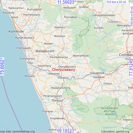
Cherpulassery GPS coordinates[2]
10° 52' 35.58" North, 76° 18' 33.552" East
| Map corner | latitude | longitude |
|---|---|---|
| Upper-left | 11.56623°, | 75.6062° |
| Center: | 10.87655°, | 76.30932° |
| Lower-right: | 10.18527°, | 77.01245° |
| Map W x H: | 153.5×153.6 km | = 95.4×95.4mi |
| max Lat: | 34.9274° ⇑93.8% North |
| Cherpulassery: | 10.87655° |
| min Lat: | ⇓6.2% South 8.09008° |
| min Long | Cherpulassery | max Long |
| 68.82655° | 76.30932° | 96.81° |
| W 29.5%⇐ | ⇒70.5% E |
Elevation
Elevation of Cherpulassery is 66 m = 217 ft, and this is 229.6 m = 753 ft below average elevation for this country.
| Max E: |
3681 m = 12077 ft | 75.6% |
| Avg. | 295.6 m = 970 ft | |
| Cherpulassery | 66 m = 217 ft | |
Min E: |
1 m = 3 ft | 24.4% |
See also: India elevation on elevation.city.
Geographical zone
Cherpulassery is located in North Torrid zone (between Equator and Tropic of Cancer). Distance of Equator is 1209.4 km =751.5 mi to South.| Distance of | km | miles | from Cherpulassery |
|---|---|---|---|
| North Pole | 8797.7 | 5466.6 | to North |
| Arctic Circle | 6191.8 | 3847.4 | to North |
| Tropic Cancer | 1396.6 | 867.8 | to North |
| Equator | 1209.4 | 751.5 | to South |


Nearby cities:
15 places around Cherpulassery: (largest is in red/bold)
• Avanoor
33.2 km =20.6 mi,  205°
205°
• Chetwayi
48.1 km =29.9 mi,  216°
216°
• Chēlakara
20.8 km =12.9 mi,  169°
169°
• Edakkulam
32.6 km =20.3 mi,  204°
204°
• Guruvāyūr
42.9 km =26.7 mi, 223°
• Kunnamkulam
36.8 km =22.9 mi,  226°
226°
• Malappuram
30.9 km =19.2 mi,  306°
306°
• Manjeri
34.1 km =21.2 mi,  322°
322°
• Mannārakkāt
21.2 km =13.2 mi,  52°
52°
• Ottappālam
13.7 km =8.5 mi,  146°
146°
• Ponnāni
43.7 km =27.2 mi,  253°
253°
• Pālghāt
39.3 km =24.4 mi,  106°
106°
• Shōranūr
13.4 km =8.3 mi, 198°
• Thrissur
41.3 km =25.7 mi,  194°
194°
• Tirur
42.6 km =26.5 mi,  275°
275°
Sources, notices
• [Note1] Compared only with cities in India existing in our database
• [Src1] Map data: © OpenStreetMap contributors (CC-BY-SA)
• [Src2] Other city data from geonames.org with taken over terms of usage.
• [Src3] Geographical zone / Annual Mean Temperature by Robert A. Rohde @ Wikipedia
