Shōranūr geodata
Shōranūr (Kerala) is a populated place; located in India in Asia/Kolkata (GMT+5.5) time zone. With population of 42,694 people, there are 1034 cities with bigger population in this country. Compared to other cities in India, 94.2% of cities are located further ↑North; 70.9% of cities are located further →East and 82.6% of cities have higher elevation than Shōranūr. Note1


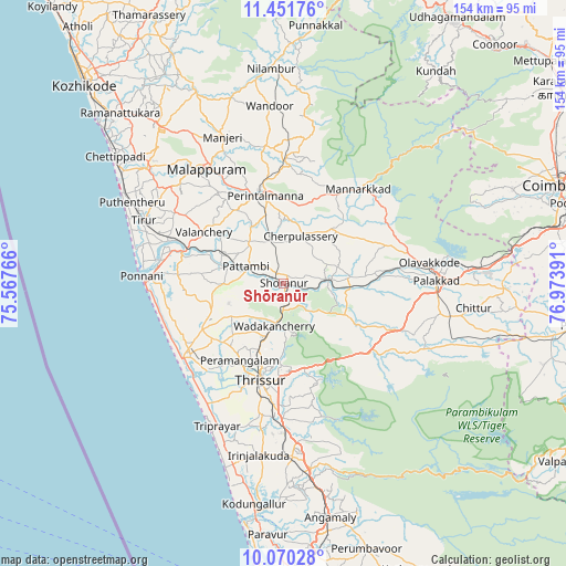
Shōranūr GPS coordinates[2]
10° 45' 42.516" North, 76° 16' 14.808" East
| Map corner | latitude | longitude |
|---|---|---|
| Upper-left | 11.45176°, | 75.56766° |
| Center: | 10.76181°, | 76.27078° |
| Lower-right: | 10.07028°, | 76.97391° |
| Map W x H: | 153.6×153.6 km | = 95.4×95.4mi |
| max Lat: | 34.9274° ⇑94.2% North |
| Shōranūr: | 10.76181° |
| min Lat: | ⇓5.8% South 8.09008° |
| min Long | Shōranūr | max Long |
| 68.82655° | 76.27078° | 96.81° |
| W 29.1%⇐ | ⇒70.9% E |
Elevation
Elevation of Shōranūr is 38 m = 125 ft, and this is 257.6 m = 845 ft below average elevation for this country.
| Max E: |
3681 m = 12077 ft | 82.6% |
| Avg. | 295.6 m = 970 ft | |
| Shōranūr | 38 m = 125 ft | |
Min E: |
1 m = 3 ft | 17.4% |
See also: Shōranūr elevation on elevation.city.
Geographical zone
Shōranūr is located in North Torrid zone (between Equator and Tropic of Cancer). Distance of Equator is 1196.6 km =743.5 mi to South.| Distance of | km | miles | from Shōranūr |
|---|---|---|---|
| North Pole | 8810.5 | 5474.6 | to North |
| Arctic Circle | 6204.6 | 3855.4 | to North |
| Tropic Cancer | 1409.3 | 875.7 | to North |
| Equator | 1196.6 | 743.5 | to South |


Nearby cities:
15 places around Shōranūr: (largest is in red/bold)
• Avanoor
20 km =12.4 mi,  211°
211°
• Cherpulassery
13.4 km =8.3 mi,  18°
18°
• Chetwayi
35.6 km =22.1 mi,  223°
223°
• Chēlakara
11.1 km =6.9 mi,  133°
133°
• Edakkulam
19.4 km =12.1 mi, 209°
• Guruvāyūr
31.3 km =19.4 mi,  233°
233°
• Kunnamkulam
25.7 km =16 mi,  240°
240°
• Malappuram
37.4 km =23.2 mi,  326°
326°
• Mannārakkāt
33.2 km =20.6 mi,  39°
39°
• Ottappālam
11.7 km =7.3 mi,  83°
83°
• Ponnāni
37.7 km =23.4 mi,  270°
270°
• Pālghāt
41.8 km =26 mi,  88°
88°
• Thanniyam
41.2 km =25.6 mi,  201°
201°
• Thrissur
27.9 km =17.3 mi,  192°
192°
• Tirur
41.7 km =25.9 mi,  293°
293°
Sources, notices
• [Note1] Compared only with cities in India existing in our database
• [Src1] Map data: © OpenStreetMap contributors (CC-BY-SA)
• [Src2] Other city data from geonames.org with taken over terms of usage.
• [Src3] Geographical zone / Annual Mean Temperature by Robert A. Rohde @ Wikipedia
