Thiruvarur geodata
Thiruvarur (Tamil Nadu) is a populated place; located in India in Asia/Kolkata (GMT+5.5) time zone. With population of 58,777 people, there are 748 cities with bigger population in this country. Compared to other cities in India, 94% of cities are located further ↑North; 65% of cities are located further ←West and 91.1% of cities have higher elevation than Thiruvarur. Note1


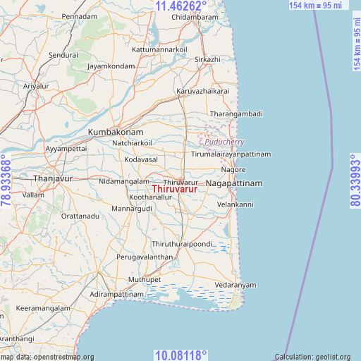
Thiruvarur GPS coordinates[2]
10° 46' 21.684" North, 79° 38' 12.48" East
| Map corner | latitude | longitude |
|---|---|---|
| Upper-left | 11.46262°, | 78.93368° |
| Center: | 10.77269°, | 79.6368° |
| Lower-right: | 10.08118°, | 80.33993° |
| Map W x H: | 153.6×153.6 km | = 95.4×95.4mi |
| max Lat: | 34.9274° ⇑94% North |
| Thiruvarur: | 10.77269° |
| min Lat: | ⇓6% South 8.09008° |
| min Long | Thiruvarur | max Long |
| 68.82655° | 79.6368° | 96.81° |
| W 65%⇐ | ⇒35% E |
Elevation
Elevation of Thiruvarur is 16 m = 52 ft, and this is 279.6 m = 917 ft below average elevation for this country.
| Max E: |
3681 m = 12077 ft | 91.1% |
| Avg. | 295.6 m = 970 ft | |
| Thiruvarur | 16 m = 52 ft | |
Min E: |
1 m = 3 ft | 8.9% |
See also: Thiruvarur elevation on elevation.city.
Geographical zone
Thiruvarur is located in North Torrid zone (between Equator and Tropic of Cancer). Distance of Equator is 1197.8 km =744.3 mi to South.| Distance of | km | miles | from Thiruvarur |
|---|---|---|---|
| North Pole | 8809.3 | 5473.8 | to North |
| Arctic Circle | 6203.4 | 3854.6 | to North |
| Tropic Cancer | 1408.1 | 875 | to North |
| Equator | 1197.8 | 744.3 | to South |


Nearby cities:
15 places around Thiruvarur: (largest is in red/bold)
• Aduthurai
31.9 km =19.8 mi,  327°
327°
• Ammāpettai
34.7 km =21.6 mi,  274°
274°
• Kilvelur
11.5 km =7.1 mi,  93°
93°
• Koothanallur
14.5 km =9 mi,  246°
246°
• Koradāchcheri
15.9 km =9.9 mi, 268°
• Kumbakonam
34.1 km =21.2 mi,  308°
308°
• Kāraikāl
26.8 km =16.7 mi,  53°
53°
• Mannargudi
23.5 km =14.6 mi,  239°
239°
• Mayiladuthurai
36.8 km =22.9 mi,  3°
3°
• Nannilam
12.2 km =7.6 mi,  346°
346°
• Needamangalam
23.8 km =14.8 mi, 270°
• Negapatam
22.6 km =14 mi, 92°
• Thiruvidaimaruthur
32.2 km =20 mi,  321°
321°
• Valangaiman
29.6 km =18.4 mi,  296°
296°
• Velankanni
23.7 km =14.7 mi,  114°
114°
Sources, notices
• [Note1] Compared only with cities in India existing in our database
• [Src1] Map data: © OpenStreetMap contributors (CC-BY-SA)
• [Src2] Other city data from geonames.org with taken over terms of usage.
• [Src3] Geographical zone / Annual Mean Temperature by Robert A. Rohde @ Wikipedia
