Velankanni geodata
Velankanni (Tamil Nadu) is a populated place; located in India in Asia/Kolkata (GMT+5.5) time zone. With population of 10,000 people, there are 2941 cities with bigger population in this country. Compared to other cities in India, 94.4% of cities are located further ↑North; 66.6% of cities are located further ←West and 99.8% of cities have higher elevation than Velankanni. Note1


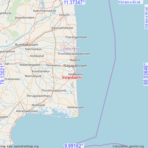
Velankanni GPS coordinates[2]
10° 40' 59.988" North, 79° 49' 59.988" East
| Map corner | latitude | longitude |
|---|---|---|
| Upper-left | 11.37347°, | 79.13021° |
| Center: | 10.68333°, | 79.83333° |
| Lower-right: | 9.99162°, | 80.53646° |
| Map W x H: | 153.6×153.6 km | = 95.4×95.4mi |
| max Lat: | 34.9274° ⇑94.4% North |
| Velankanni: | 10.68333° |
| min Lat: | ⇓5.6% South 8.09008° |
| min Long | Velankanni | max Long |
| 68.82655° | 79.83333° | 96.81° |
| W 66.6%⇐ | ⇒33.4% E |
Elevation
Elevation of Velankanni is 3 m = 10 ft, and this is 292.6 m = 960 ft below average elevation for this country.
| Max E: |
3681 m = 12077 ft | 99.8% |
| Avg. | 295.6 m = 970 ft | |
| Velankanni | 3 m = 10 ft | |
Min E: |
1 m = 3 ft | 0.2% |
See also: India elevation on elevation.city.
Geographical zone
Velankanni is located in North Torrid zone (between Equator and Tropic of Cancer). Distance of Equator is 1187.9 km =738.1 mi to South.| Distance of | km | miles | from Velankanni |
|---|---|---|---|
| North Pole | 8819.2 | 5480 | to North |
| Arctic Circle | 6213.3 | 3860.8 | to North |
| Tropic Cancer | 1418 | 881.1 | to North |
| Equator | 1187.9 | 738.1 | to South |


Nearby cities:
15 places around Velankanni: (largest is in red/bold)
• Kilvelur
13.7 km =8.5 mi,  313°
313°
• Koothanallur
34.9 km =21.7 mi,  276°
276°
• Koradāchcheri
38.6 km =24 mi, 284°
• Kāraikāl
25.9 km =16.1 mi,  0°
0°
• Madukkūr
52.5 km =32.6 mi,  244°
244°
• Mannargudi
41.9 km =26 mi,  267°
267°
• Mayiladuthurai
50.6 km =31.4 mi,  337°
337°
• Muttupet
49.1 km =30.5 mi,  229°
229°
• Nannilam
32.7 km =20.3 mi, 311°
• Needamangalam
46.4 km =28.8 mi, 282°
• Negapatam
9 km =5.6 mi,  6°
6°
• Tharangambadi
38.4 km =23.9 mi, 3°
• Thiruvarur
23.7 km =14.7 mi,  294°
294°
• Valangaiman
53.3 km =33.1 mi,  295°
295°
• Vedaraniyam
34.7 km =21.6 mi,  176°
176°
Sources, notices
• [Note1] Compared only with cities in India existing in our database
• [Src1] Map data: © OpenStreetMap contributors (CC-BY-SA)
• [Src2] Other city data from geonames.org with taken over terms of usage.
• [Src3] Geographical zone / Annual Mean Temperature by Robert A. Rohde @ Wikipedia
