Negapatam geodata
Negapatam (Tamil Nadu) is a populated place; located in India in Asia/Kolkata (GMT+5.5) time zone. With population of 94,238 people, there are 472 cities with bigger population in this country. Compared to other cities in India, 94.2% of cities are located further ↑North; 66.8% of cities are located further ←West and 96.4% of cities have higher elevation than Negapatam. Note1


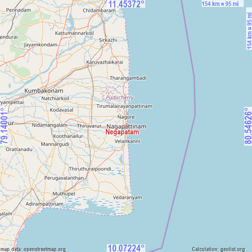
Negapatam GPS coordinates[2]
10° 45' 49.572" North, 79° 50' 35.268" East
| Map corner | latitude | longitude |
|---|---|---|
| Upper-left | 11.45372°, | 79.14001° |
| Center: | 10.76377°, | 79.84313° |
| Lower-right: | 10.07224°, | 80.54626° |
| Map W x H: | 153.6×153.6 km | = 95.4×95.4mi |
| max Lat: | 34.9274° ⇑94.2% North |
| Negapatam: | 10.76377° |
| min Lat: | ⇓5.8% South 8.09008° |
| min Long | Negapatam | max Long |
| 68.82655° | 79.84313° | 96.81° |
| W 66.8%⇐ | ⇒33.2% E |
Elevation
Elevation of Negapatam is 10 m = 33 ft, and this is 285.6 m = 937 ft below average elevation for this country.
| Max E: |
3681 m = 12077 ft | 96.4% |
| Avg. | 295.6 m = 970 ft | |
| Negapatam | 10 m = 33 ft | |
Min E: |
1 m = 3 ft | 3.6% |
See also: Negapatam elevation on elevation.city.
Geographical zone
Negapatam is located in North Torrid zone (between Equator and Tropic of Cancer). Distance of Equator is 1196.8 km =743.7 mi to South.| Distance of | km | miles | from Negapatam |
|---|---|---|---|
| North Pole | 8810.2 | 5474.4 | to North |
| Arctic Circle | 6204.4 | 3855.2 | to North |
| Tropic Cancer | 1409.1 | 875.6 | to North |
| Equator | 1196.8 | 743.7 | to South |


Nearby cities:
15 places around Negapatam: (largest is in red/bold)
• Aduthurai
48.4 km =30.1 mi,  305°
305°
• Kilvelur
11.1 km =6.9 mi,  271°
271°
• Koothanallur
36.1 km =22.4 mi,  262°
262°
• Koradāchcheri
38.4 km =23.9 mi, 271°
• Kāraikāl
17 km =10.6 mi,  356°
356°
• Mannargudi
44.2 km =27.5 mi, 255°
• Mayiladuthurai
43 km =26.7 mi,  331°
331°
• Nannilam
28.5 km =17.7 mi,  296°
296°
• Needamangalam
46.4 km =28.8 mi, 271°
• Tharangambadi
29.4 km =18.3 mi,  2°
2°
• Thiruvarur
22.6 km =14 mi, 272°
• Thiruvidaimaruthur
50 km =31.1 mi, 301°
• Valangaiman
51.1 km =31.8 mi,  285°
285°
• Vedaraniyam
43.6 km =27.1 mi,  178°
178°
• Velankanni
9 km =5.6 mi,  186°
186°
Sources, notices
• [Note1] Compared only with cities in India existing in our database
• [Src1] Map data: © OpenStreetMap contributors (CC-BY-SA)
• [Src2] Other city data from geonames.org with taken over terms of usage.
• [Src3] Geographical zone / Annual Mean Temperature by Robert A. Rohde @ Wikipedia
