Mannargudi geodata
Mannargudi (Tamil Nadu) is a populated place; located in India in Asia/Kolkata (GMT+5.5) time zone. With population of 63,148 people, there are 699 cities with bigger population in this country. Compared to other cities in India, 94.5% of cities are located further ↑North; 63.2% of cities are located further ←West and 87.6% of cities have higher elevation than Mannargudi. Note1


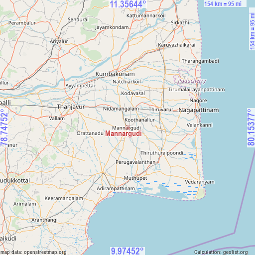
Mannargudi GPS coordinates[2]
10° 39' 58.536" North, 79° 27' 2.304" East
| Map corner | latitude | longitude |
|---|---|---|
| Upper-left | 11.35644°, | 78.74752° |
| Center: | 10.66626°, | 79.45064° |
| Lower-right: | 9.97452°, | 80.15377° |
| Map W x H: | 153.7×153.7 km | = 95.5×95.5mi |
| max Lat: | 34.9274° ⇑94.5% North |
| Mannargudi: | 10.66626° |
| min Lat: | ⇓5.5% South 8.09008° |
| min Long | Mannargudi | max Long |
| 68.82655° | 79.45064° | 96.81° |
| W 63.2%⇐ | ⇒36.8% E |
Elevation
Elevation of Mannargudi is 23 m = 75 ft, and this is 272.6 m = 894 ft below average elevation for this country.
| Max E: |
3681 m = 12077 ft | 87.6% |
| Avg. | 295.6 m = 970 ft | |
| Mannargudi | 23 m = 75 ft | |
Min E: |
1 m = 3 ft | 12.4% |
See also: Mannargudi elevation on elevation.city.
Geographical zone
Mannargudi is located in North Torrid zone (between Equator and Tropic of Cancer). Distance of Equator is 1186 km =736.9 mi to South.| Distance of | km | miles | from Mannargudi |
|---|---|---|---|
| North Pole | 8821.1 | 5481.2 | to North |
| Arctic Circle | 6215.2 | 3861.9 | to North |
| Tropic Cancer | 1419.9 | 882.3 | to North |
| Equator | 1186 | 736.9 | to South |


Nearby cities:
15 places around Mannargudi: (largest is in red/bold)
• Ammāpettai
20.2 km =12.6 mi,  315°
315°
• Kilvelur
33.7 km =20.9 mi,  70°
70°
• Koothanallur
9.3 km =5.8 mi,  50°
50°
• Koradāchcheri
12.4 km =7.7 mi,  21°
21°
• Kumbakonam
33.5 km =20.8 mi,  348°
348°
• Madukkūr
21.3 km =13.2 mi,  195°
195°
• Muttupet
30.5 km =19 mi,  171°
171°
• Nannilam
29.4 km =18.3 mi,  36°
36°
• Needamangalam
12.5 km =7.8 mi,  343°
343°
• Papanasam
35 km =21.7 mi,  325°
325°
• Pattukkottai
30.6 km =19 mi,  207°
207°
• Swāmimalai
35 km =21.7 mi, 337°
• Tanjore
36.5 km =22.7 mi,  291°
291°
• Thiruvarur
23.5 km =14.6 mi,  59°
59°
• Valangaiman
25.7 km =16 mi, 345°
Sources, notices
• [Note1] Compared only with cities in India existing in our database
• [Src1] Map data: © OpenStreetMap contributors (CC-BY-SA)
• [Src2] Other city data from geonames.org with taken over terms of usage.
• [Src3] Geographical zone / Annual Mean Temperature by Robert A. Rohde @ Wikipedia
