Godhra geodata
Godhra (Gujarat) is a populated place; located in India in Asia/Kolkata (GMT+5.5) time zone. With population of 131,913 people, there are 330 cities with bigger population in this country. Compared to other cities in India, 50.2% of cities are located further ↑North; 92.1% of cities are located further →East and 63.1% of cities have higher elevation than Godhra. Note1


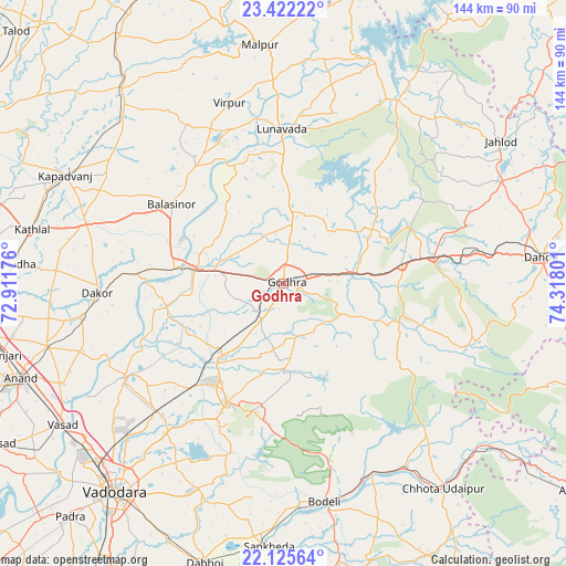
Godhra GPS coordinates[2]
22° 46' 31.692" North, 73° 36' 53.568" East
| Map corner | latitude | longitude |
|---|---|---|
| Upper-left | 23.42222°, | 72.91176° |
| Center: | 22.77547°, | 73.61488° |
| Lower-right: | 22.12564°, | 74.31801° |
| Map W x H: | 144.2×144.2 km | = 89.6×89.6mi |
| max Lat: | 34.9274° ⇑50.2% North |
| Godhra: | 22.77547° |
| min Lat: | ⇓49.8% South 8.09008° |
| min Long | Godhra | max Long |
| 68.82655° | 73.61488° | 96.81° |
| W 7.9%⇐ | ⇒92.1% E |
Elevation
Elevation of Godhra is 132 m = 433 ft, and this is 163.6 m = 537 ft below average elevation for this country.
| Max E: |
3681 m = 12077 ft | 63.1% |
| Avg. | 295.6 m = 970 ft | |
| Godhra | 132 m = 433 ft | |
Min E: |
1 m = 3 ft | 36.9% |
See also: Godhra elevation on elevation.city.
Geographical zone
Godhra is located in North Torrid zone (between Equator and Tropic of Cancer). Distance of this Northern Tropic circle is 73.5 km =45.7 mi to North.| Distance of | km | miles | from Godhra |
|---|---|---|---|
| North Pole | 7474.7 | 4644.6 | to North |
| Arctic Circle | 4868.8 | 3025.3 | to North |
| Tropic Cancer | 73.5 | 45.7 | to North |
| Equator | 2532.4 | 1573.6 | to South |


Nearby cities:
15 places around Godhra: (largest is in red/bold)
• Devgadh Bāriya
31.1 km =19.3 mi,  104°
104°
• Dohad
66.4 km =41.3 mi,  84°
84°
• Dākor
47.8 km =29.7 mi,  266°
266°
• Hālol
33.6 km =20.9 mi,  205°
205°
• Jetpur
53.2 km =33.1 mi,  154°
154°
• Kapadvanj
62.1 km =38.6 mi,  296°
296°
• Kālol
24.3 km =15.1 mi,  219°
219°
• Lūnāvāda
39.2 km =24.4 mi,  359°
359°
• Morwa
27.1 km =16.8 mi,  57°
57°
• Shivrājpur
39.2 km =24.4 mi,  180°
180°
• Thāsra
41.4 km =25.7 mi, 273°
• Umreth
51.9 km =32.2 mi,  260°
260°
• Vejalpur
10.9 km =6.8 mi, 209°
• Virpur
48 km =29.8 mi,  343°
343°
• Vāghodia
56.8 km =35.3 mi,  202°
202°
Sources, notices
• [Note1] Compared only with cities in India existing in our database
• [Src1] Map data: © OpenStreetMap contributors (CC-BY-SA)
• [Src2] Other city data from geonames.org with taken over terms of usage.
• [Src3] Geographical zone / Annual Mean Temperature by Robert A. Rohde @ Wikipedia
