Hālol geodata
Hālol (Gujarat) is a populated place; located in India in Asia/Kolkata (GMT+5.5) time zone. With population of 45,741 people, there are 967 cities with bigger population in this country. Compared to other cities in India, 53.1% of cities are located further ↑North; 92.6% of cities are located further →East and 66.6% of cities have higher elevation than Hālol. Note1


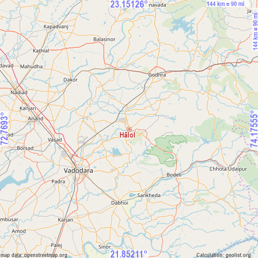
Hālol GPS coordinates[2]
22° 30' 11.556" North, 73° 28' 20.712" East
| Map corner | latitude | longitude |
|---|---|---|
| Upper-left | 23.15126°, | 72.7693° |
| Center: | 22.50321°, | 73.47242° |
| Lower-right: | 21.85211°, | 74.17555° |
| Map W x H: | 144.5×144.5 km | = 89.8×89.8mi |
| max Lat: | 34.9274° ⇑53.1% North |
| Hālol: | 22.50321° |
| min Lat: | ⇓46.9% South 8.09008° |
| min Long | Hālol | max Long |
| 68.82655° | 73.47242° | 96.81° |
| W 7.4%⇐ | ⇒92.6% E |
Elevation
Elevation of Hālol is 109 m = 358 ft, and this is 186.6 m = 612 ft below average elevation for this country.
| Max E: |
3681 m = 12077 ft | 66.6% |
| Avg. | 295.6 m = 970 ft | |
| Hālol | 109 m = 358 ft | |
Min E: |
1 m = 3 ft | 33.4% |
See also: Hālol elevation on elevation.city.
Geographical zone
Hālol is located in North Torrid zone (between Equator and Tropic of Cancer). Distance of this Northern Tropic circle is 103.8 km =64.5 mi to North.| Distance of | km | miles | from Hālol |
|---|---|---|---|
| North Pole | 7504.9 | 4663.3 | to North |
| Arctic Circle | 4899.1 | 3044.2 | to North |
| Tropic Cancer | 103.8 | 64.5 | to North |
| Equator | 2502.1 | 1554.7 | to South |


Nearby cities:
15 places around Hālol: (largest is in red/bold)
• Anand
53.4 km =33.2 mi,  275°
275°
• Dabhoi
35.8 km =22.2 mi,  186°
186°
• Devgadh Bāriya
50.1 km =31.1 mi,  63°
63°
• Dākor
43.2 km =26.8 mi,  309°
309°
• Godhra
33.6 km =20.9 mi,  25°
25°
• Jetpur
41.8 km =26 mi,  114°
114°
• Kālol
11.7 km =7.3 mi,  355°
355°
• Padra
49.5 km =30.8 mi,  233°
233°
• Sankheda
38.6 km =24 mi,  163°
163°
• Shivrājpur
16.6 km =10.3 mi,  122°
122°
• Thāsra
42.3 km =26.3 mi,  320°
320°
• Umreth
42.6 km =26.5 mi,  300°
300°
• Vadodara
35.4 km =22 mi, 230°
• Vejalpur
22.8 km =14.2 mi,  24°
24°
• Vāghodia
23.3 km =14.5 mi,  198°
198°
Sources, notices
• [Note1] Compared only with cities in India existing in our database
• [Src1] Map data: © OpenStreetMap contributors (CC-BY-SA)
• [Src2] Other city data from geonames.org with taken over terms of usage.
• [Src3] Geographical zone / Annual Mean Temperature by Robert A. Rohde @ Wikipedia
