Kālol geodata
Kālol (Gujarat) is a populated place; located in India in Asia/Kolkata (GMT+5.5) time zone. With population of 25,929 people, there are 1641 cities with bigger population in this country. Compared to other cities in India, 52.1% of cities are located further ↑North; 92.7% of cities are located further →East and 71% of cities have higher elevation than Kālol. Note1


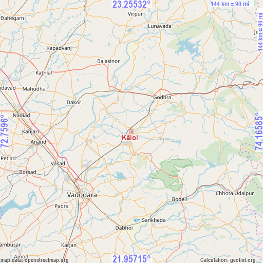
Kālol GPS coordinates[2]
22° 36' 27.972" North, 73° 27' 45.792" East
| Map corner | latitude | longitude |
|---|---|---|
| Upper-left | 23.25532°, | 72.7596° |
| Center: | 22.60777°, | 73.46272° |
| Lower-right: | 21.95715°, | 74.16585° |
| Map W x H: | 144.3×144.3 km | = 89.7×89.7mi |
| max Lat: | 34.9274° ⇑52.1% North |
| Kālol: | 22.60777° |
| min Lat: | ⇓47.9% South 8.09008° |
| min Long | Kālol | max Long |
| 68.82655° | 73.46272° | 96.81° |
| W 7.3%⇐ | ⇒92.7% E |
Elevation
Elevation of Kālol is 88 m = 289 ft, and this is 207.6 m = 681 ft below average elevation for this country.
| Max E: |
3681 m = 12077 ft | 71% |
| Avg. | 295.6 m = 970 ft | |
| Kālol | 88 m = 289 ft | |
Min E: |
1 m = 3 ft | 29% |
See also: India elevation on elevation.city.
Geographical zone
Kālol is located in North Torrid zone (between Equator and Tropic of Cancer). Distance of this Northern Tropic circle is 92.2 km =57.3 mi to North.| Distance of | km | miles | from Kālol |
|---|---|---|---|
| North Pole | 7493.3 | 4656.1 | to North |
| Arctic Circle | 4887.4 | 3036.9 | to North |
| Tropic Cancer | 92.2 | 57.3 | to North |
| Equator | 2513.7 | 1561.9 | to South |


Nearby cities:
15 places around Kālol: (largest is in red/bold)
• Anand
52.5 km =32.6 mi,  263°
263°
• Dabhoi
47.3 km =29.4 mi,  183°
183°
• Devgadh Bāriya
47 km =29.2 mi,  76°
76°
• Dākor
35.9 km =22.3 mi,  296°
296°
• Godhra
24.3 km =15.1 mi,  39°
39°
• Hālol
11.7 km =7.3 mi, 175°
• Jetpur
48.6 km =30.2 mi,  126°
126°
• Morwa
50.8 km =31.6 mi,  49°
49°
• Sankheda
50.1 km =31.1 mi,  166°
166°
• Shivrājpur
25.4 km =15.8 mi,  143°
143°
• Thāsra
33.3 km =20.7 mi,  309°
309°
• Umreth
37 km =23 mi,  285°
285°
• Vadodara
43.1 km =26.8 mi,  217°
217°
• Vejalpur
13.8 km =8.6 mi, 48°
• Vāghodia
34.3 km =21.3 mi,  190°
190°
Sources, notices
• [Note1] Compared only with cities in India existing in our database
• [Src1] Map data: © OpenStreetMap contributors (CC-BY-SA)
• [Src2] Other city data from geonames.org with taken over terms of usage.
• [Src3] Geographical zone / Annual Mean Temperature by Robert A. Rohde @ Wikipedia
