Thenkasi geodata
Thenkasi (Tamil Nadu) is a populated place; located in India in Asia/Kolkata (GMT+5.5) time zone. With population of 65,496 people, there are 667 cities with bigger population in this country. Compared to other cities in India, 98.9% of cities are located further ↑North; 59.5% of cities are located further →East and 56% of cities have higher elevation than Thenkasi. Note1


Thenkasi GPS coordinates[2]
8° 57' 36.108" North, 77° 18' 54.9" East
| Map corner | latitude | longitude |
|---|---|---|
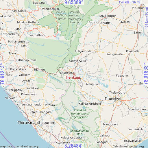
| Upper-left | 9.65389°, | 76.61213° |
| Center: | 8.96003°, | 77.31525° |
| Lower-right: | 8.26484°, | 78.01838° |
| Map W x H: | 154.4×154.5 km | = 95.9×96mi |
| max Lat: | 34.9274° ⇑98.9% North |
| Thenkasi: | 8.96003° |
| min Lat: | ⇓1.1% South 8.09008° |
| min Long | Thenkasi | max Long |
| 68.82655° | 77.31525° | 96.81° |
| W 40.5%⇐ | ⇒59.5% E |
Elevation
Elevation of Thenkasi is 170 m = 558 ft, and this is 125.6 m = 412 ft below average elevation for this country.
| Max E: |
3681 m = 12077 ft | 56% |
| Avg. | 295.6 m = 970 ft | |
| Thenkasi | 170 m = 558 ft | |
Min E: |
1 m = 3 ft | 44% |
See also: Thenkasi elevation on elevation.city.
Geographical zone
Thenkasi is located in North Torrid zone (between Equator and Tropic of Cancer). Distance of Equator is 996.3 km =619.1 mi to South.| Distance of | km | miles | from Thenkasi |
|---|---|---|---|
| North Pole | 9010.8 | 5599 | to North |
| Arctic Circle | 6404.9 | 3979.8 | to North |
| Tropic Cancer | 1609.7 | 1000.2 | to North |
| Equator | 996.3 | 619.1 | to South |


Nearby cities:
15 places around Thenkasi: (largest is in red/bold)
• Ambasamudram
31.5 km =19.6 mi,  151°
151°
• Cholapuram
51.7 km =32.1 mi,  32°
32°
• Kadayanallur
12.9 km =8 mi,  12°
12°
• Kallidaikurichi
34.7 km =21.6 mi, 151°
• Kalugumalai
47.8 km =29.7 mi,  63°
63°
• Kayattār
50.4 km =31.3 mi,  91°
91°
• Kuttālam
6 km =3.7 mi,  236°
236°
• Puliyangudi
25.6 km =15.9 mi,  20°
20°
• Punalūr
43.6 km =27.1 mi,  278°
278°
• Sivagiri
44.6 km =27.7 mi, 16°
• Sūrandai
11.6 km =7.2 mi,  81°
81°
• Tirunelveli
48 km =29.8 mi,  122°
122°
• Vadakku Viravanallur
36.8 km =22.9 mi,  142°
142°
• Vāsudevanallūr
33.1 km =20.6 mi, 18°
• Ālangulam
22.9 km =14.2 mi, 117°
Sources, notices
• [Note1] Compared only with cities in India existing in our database
• [Src1] Map data: © OpenStreetMap contributors (CC-BY-SA)
• [Src2] Other city data from geonames.org with taken over terms of usage.
• [Src3] Geographical zone / Annual Mean Temperature by Robert A. Rohde @ Wikipedia
