Vāsudevanallūr geodata
Vāsudevanallūr (Tamil Nadu) is a populated place; located in India in Asia/Kolkata (GMT+5.5) time zone. With population of 19,021 people, there are 2121 cities with bigger population in this country. Compared to other cities in India, 98.4% of cities are located further ↑North; 58.3% of cities are located further →East and 53.8% of cities have higher elevation than Vāsudevanallūr. Note1


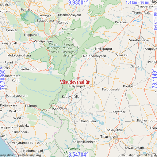
Vāsudevanallūr GPS coordinates[2]
9° 14' 30.156" North, 77° 24' 42.372" East
| Map corner | latitude | longitude |
|---|---|---|
| Upper-left | 9.93501°, | 76.70865° |
| Center: | 9.24171°, | 77.41177° |
| Lower-right: | 8.54704°, | 78.1149° |
| Map W x H: | 154.3×154.3 km | = 95.9×95.9mi |
| max Lat: | 34.9274° ⇑98.4% North |
| Vāsudevanallūr: | 9.24171° |
| min Lat: | ⇓1.6% South 8.09008° |
| min Long | Vāsudevanallū | max Long |
| 68.82655° | 77.41177° | 96.81° |
| W 41.7%⇐ | ⇒58.3% E |
Elevation
Elevation of Vāsudevanallūr is 181 m = 594 ft, and this is 114.6 m = 376 ft below average elevation for this country.
| Max E: |
3681 m = 12077 ft | 53.8% |
| Avg. | 295.6 m = 970 ft | |
| Vāsudevanallūr | 181 m = 594 ft | |
Min E: |
1 m = 3 ft | 46.2% |
See also: India elevation on elevation.city.
Geographical zone
Vāsudevanallūr is located in North Torrid zone (between Equator and Tropic of Cancer). Distance of Equator is 1027.6 km =638.5 mi to South.| Distance of | km | miles | from Vāsudevanallūr |
|---|---|---|---|
| North Pole | 8979.5 | 5579.6 | to North |
| Arctic Circle | 6373.6 | 3960.4 | to North |
| Tropic Cancer | 1578.3 | 980.7 | to North |
| Equator | 1027.6 | 638.5 | to South |


Nearby cities:
15 places around Vāsudevanallūr: (largest is in red/bold)
• Cholapuram
21.1 km =13.1 mi,  54°
54°
• Elāyirampannai
45.5 km =28.3 mi,  85°
85°
• Kadayanallur
20.3 km =12.6 mi,  202°
202°
• Kalugumalai
33.9 km =21.1 mi,  107°
107°
• Kayattār
51.5 km =32 mi,  129°
129°
• Kovilpatti
50.9 km =31.6 mi,  98°
98°
• Kuttālam
38 km =23.6 mi, 204°
• Puliyangudi
7.6 km =4.7 mi,  191°
191°
• Rajapalaiyam
28.2 km =17.5 mi,  33°
33°
• Sivagiri
11.6 km =7.2 mi,  9°
9°
• Sivakasi
48.3 km =30 mi,  61°
61°
• Srivilliputhur
38.7 km =24 mi,  38°
38°
• Sūrandai
29.6 km =18.4 mi,  178°
178°
• Thenkasi
33.1 km =20.6 mi, 198°
• Ālangulam
43.1 km =26.8 mi,  167°
167°
Sources, notices
• [Note1] Compared only with cities in India existing in our database
• [Src1] Map data: © OpenStreetMap contributors (CC-BY-SA)
• [Src2] Other city data from geonames.org with taken over terms of usage.
• [Src3] Geographical zone / Annual Mean Temperature by Robert A. Rohde @ Wikipedia
