Kayattār geodata
Kayattār (Tamil Nadu) is a populated place; located in India in Asia/Kolkata (GMT+5.5) time zone. With population of 10,007 people, there are 2940 cities with bigger population in this country. Compared to other cities in India, 98.9% of cities are located further ↑North; 54% of cities are located further →East and 76.1% of cities have higher elevation than Kayattār. Note1


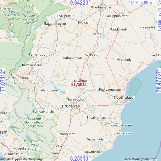
Kayattār GPS coordinates[2]
8° 56' 54.024" North, 77° 46' 27.264" East
| Map corner | latitude | longitude |
|---|---|---|
| Upper-left | 9.64223°, | 77.07112° |
| Center: | 8.94834°, | 77.77424° |
| Lower-right: | 8.25313°, | 78.47737° |
| Map W x H: | 154.5×154.5 km | = 96×96mi |
| max Lat: | 34.9274° ⇑98.9% North |
| Kayattār: | 8.94834° |
| min Lat: | ⇓1.1% South 8.09008° |
| min Long | Kayattār | max Long |
| 68.82655° | 77.77424° | 96.81° |
| W 46%⇐ | ⇒54% E |
Elevation
Elevation of Kayattār is 63 m = 207 ft, and this is 232.6 m = 763 ft below average elevation for this country.
| Max E: |
3681 m = 12077 ft | 76.1% |
| Avg. | 295.6 m = 970 ft | |
| Kayattār | 63 m = 207 ft | |
Min E: |
1 m = 3 ft | 23.9% |
See also: India elevation on elevation.city.
Geographical zone
Kayattār is located in North Torrid zone (between Equator and Tropic of Cancer). Distance of Equator is 995 km =618.3 mi to South.| Distance of | km | miles | from Kayattār |
|---|---|---|---|
| North Pole | 9012.1 | 5599.9 | to North |
| Arctic Circle | 6406.2 | 3980.6 | to North |
| Tropic Cancer | 1611 | 1001 | to North |
| Equator | 995 | 618.3 | to South |


Nearby cities:
15 places around Kayattār: (largest is in red/bold)
• Alwa Tirunagari
42.2 km =26.2 mi,  154°
154°
• Ambasamudram
44.2 km =27.5 mi,  233°
233°
• Elāyirampannai
36.2 km =22.5 mi,  8°
8°
• Ettaiyapuram
32.2 km =20 mi,  47°
47°
• Gangaikondān
10.1 km =6.3 mi,  176°
176°
• Kadambūr
11.1 km =6.9 mi,  60°
60°
• Kalugumalai
23.6 km =14.7 mi,  341°
341°
• Korampallam
39.8 km =24.7 mi,  118°
118°
• Kovilpatti
27 km =16.8 mi,  22°
22°
• Srivaikuntam
38.6 km =24 mi,  156°
156°
• Sūrandai
39.1 km =24.3 mi,  274°
274°
• Thoothukudi
44.4 km =27.6 mi, 116°
• Tirunelveli
26.5 km =16.5 mi,  202°
202°
• Vadakku Viravanallur
39.5 km =24.5 mi, 225°
• Ālangulam
31.6 km =19.6 mi,  252°
252°
Sources, notices
• [Note1] Compared only with cities in India existing in our database
• [Src1] Map data: © OpenStreetMap contributors (CC-BY-SA)
• [Src2] Other city data from geonames.org with taken over terms of usage.
• [Src3] Geographical zone / Annual Mean Temperature by Robert A. Rohde @ Wikipedia
