Cholapuram geodata
Cholapuram (Tamil Nadu) is a populated place; located in India in Asia/Kolkata (GMT+5.5) time zone. With population of 6,557 people, there are 3246 cities with bigger population in this country. Compared to other cities in India, 98.1% of cities are located further ↑North; 56.4% of cities are located further →East and 64% of cities have higher elevation than Cholapuram. Note1


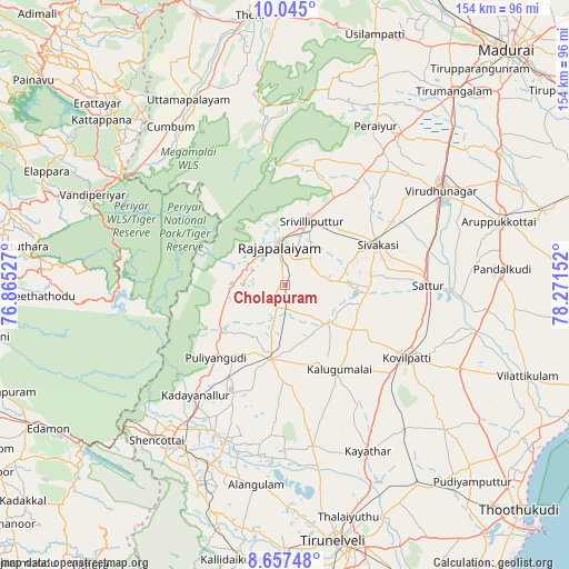
Cholapuram GPS coordinates[2]
9° 21' 6.948" North, 77° 34' 6.204" East
| Map corner | latitude | longitude |
|---|---|---|
| Upper-left | 10.045°, | 76.86527° |
| Center: | 9.35193°, | 77.56839° |
| Lower-right: | 8.65748°, | 78.27152° |
| Map W x H: | 154.3×154.3 km | = 95.9×95.9mi |
| max Lat: | 34.9274° ⇑98.1% North |
| Cholapuram: | 9.35193° |
| min Lat: | ⇓1.9% South 8.09008° |
| min Long | Cholapuram | max Long |
| 68.82655° | 77.56839° | 96.81° |
| W 43.6%⇐ | ⇒56.4% E |
Elevation
Elevation of Cholapuram is 127 m = 417 ft, and this is 168.6 m = 553 ft below average elevation for this country.
| Max E: |
3681 m = 12077 ft | 64% |
| Avg. | 295.6 m = 970 ft | |
| Cholapuram | 127 m = 417 ft | |
Min E: |
1 m = 3 ft | 36% |
See also: India elevation on elevation.city.
Geographical zone
Cholapuram is located in North Torrid zone (between Equator and Tropic of Cancer). Distance of Equator is 1039.8 km =646.1 mi to South.| Distance of | km | miles | from Cholapuram |
|---|---|---|---|
| North Pole | 8967.2 | 5572 | to North |
| Arctic Circle | 6361.3 | 3952.7 | to North |
| Tropic Cancer | 1566.1 | 973.1 | to North |
| Equator | 1039.8 | 646.1 | to South |


Nearby cities:
15 places around Cholapuram: (largest is in red/bold)
• Elāyirampannai
29.6 km =18.4 mi,  107°
107°
• Kadayanallur
39.8 km =24.7 mi,  218°
218°
• Kalugumalai
27.1 km =16.8 mi,  146°
146°
• Kovilpatti
38.7 km =24 mi,  121°
121°
• Peraiyur
49.1 km =30.5 mi,  29°
29°
• Puliyangudi
27.2 km =16.9 mi, 223°
• Rajapalaiyam
11.4 km =7.1 mi,  351°
351°
• Sattur
39.1 km =24.3 mi,  89°
89°
• Sivagiri
15.3 km =9.5 mi,  266°
266°
• Sivakasi
27.4 km =17 mi,  66°
66°
• Srivilliputhur
19.3 km =12 mi,  21°
21°
• Sūrandai
44.9 km =27.9 mi,  201°
201°
• Tiruttangal
32.5 km =20.2 mi,  63°
63°
• Virudunagar
50 km =31.1 mi, 58°
• Vāsudevanallūr
21.1 km =13.1 mi,  234°
234°
Sources, notices
• [Note1] Compared only with cities in India existing in our database
• [Src1] Map data: © OpenStreetMap contributors (CC-BY-SA)
• [Src2] Other city data from geonames.org with taken over terms of usage.
• [Src3] Geographical zone / Annual Mean Temperature by Robert A. Rohde @ Wikipedia
