Panruti geodata
Panruti (Tamil Nadu) is a populated place; located in India in Asia/Kolkata (GMT+5.5) time zone. With population of 56,586 people, there are 782 cities with bigger population in this country. Compared to other cities in India, 90.3% of cities are located further ↑North; 64.3% of cities are located further ←West and 86% of cities have higher elevation than Panruti. Note1


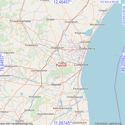
Panruti GPS coordinates[2]
11° 46' 35.832" North, 79° 33' 9.684" East
| Map corner | latitude | longitude |
|---|---|---|
| Upper-left | 12.46407°, | 78.84957° |
| Center: | 11.77662°, | 79.55269° |
| Lower-right: | 11.08745°, | 80.25582° |
| Map W x H: | 153.1×153.1 km | = 95.1×95.1mi |
| max Lat: | 34.9274° ⇑90.3% North |
| Panruti: | 11.77662° |
| min Lat: | ⇓9.7% South 8.09008° |
| min Long | Panruti | max Long |
| 68.82655° | 79.55269° | 96.81° |
| W 64.3%⇐ | ⇒35.7% E |
Elevation
Elevation of Panruti is 27 m = 89 ft, and this is 268.6 m = 881 ft below average elevation for this country.
| Max E: |
3681 m = 12077 ft | 86% |
| Avg. | 295.6 m = 970 ft | |
| Panruti | 27 m = 89 ft | |
Min E: |
1 m = 3 ft | 14% |
See also: Panruti elevation on elevation.city.
Geographical zone
Panruti is located in North Torrid zone (between Equator and Tropic of Cancer). Distance of this Northern Tropic circle is 1296.5 km =805.6 mi to North.| Distance of | km | miles | from Panruti |
|---|---|---|---|
| North Pole | 8697.6 | 5404.4 | to North |
| Arctic Circle | 6091.7 | 3785.2 | to North |
| Tropic Cancer | 1296.5 | 805.6 | to North |
| Equator | 1309.4 | 813.6 | to South |


Nearby cities:
15 places around Panruti: (largest is in red/bold)
• Annāmalainagar
46.3 km =28.8 mi,  154°
154°
• Auroville
37.7 km =23.4 mi,  47°
47°
• Chidambaram
44.6 km =27.7 mi,  160°
160°
• Cuddalore
23.4 km =14.5 mi,  95°
95°
• Kurinjippādi
25.5 km =15.8 mi,  170°
170°
• Kīl Bhuvanagiri
38.6 km =24 mi, 164°
• Nellikkuppam
12.8 km =8 mi,  90°
90°
• Puducherry
34.9 km =21.7 mi,  59°
59°
• Srīmushnam
44.8 km =27.8 mi,  201°
201°
• Tirukkoyilur
43.5 km =27 mi,  298°
298°
• Valavanur
16.4 km =10.2 mi,  11°
11°
• Vikravāndi
28.9 km =18 mi,  358°
358°
• Villupuram
19.3 km =12 mi,  340°
340°
• Vriddhāchalam
38 km =23.6 mi,  220°
220°
• Ālappākkam
26.8 km =16.7 mi,  137°
137°
Sources, notices
• [Note1] Compared only with cities in India existing in our database
• [Src1] Map data: © OpenStreetMap contributors (CC-BY-SA)
• [Src2] Other city data from geonames.org with taken over terms of usage.
• [Src3] Geographical zone / Annual Mean Temperature by Robert A. Rohde @ Wikipedia
