Shāhāpur geodata
Shāhāpur (Maharashtra) is a populated place; located in India in Asia/Kolkata (GMT+5.5) time zone. With population of 10,965 people, there are 2836 cities with bigger population in this country. Compared to other cities in India, 67.1% of cities are located further ↑North; 93.2% of cities are located further →East and 77% of cities have higher elevation than Shāhāpur. Note1


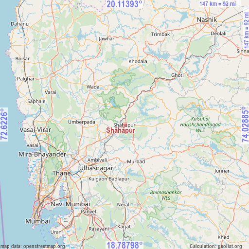
Shāhāpur GPS coordinates[2]
19° 27' 8.316" North, 73° 19' 32.592" East
| Map corner | latitude | longitude |
|---|---|---|
| Upper-left | 20.11393°, | 72.6226° |
| Center: | 19.45231°, | 73.32572° |
| Lower-right: | 18.78798°, | 74.02885° |
| Map W x H: | 147.4×147.4 km | = 91.6×91.6mi |
| max Lat: | 34.9274° ⇑67.1% North |
| Shāhāpur: | 19.45231° |
| min Lat: | ⇓32.9% South 8.09008° |
| min Long | Shāhāpur | max Long |
| 68.82655° | 73.32572° | 96.81° |
| W 6.8%⇐ | ⇒93.2% E |
Elevation
Elevation of Shāhāpur is 59 m = 194 ft, and this is 236.6 m = 776 ft below average elevation for this country.
| Max E: |
3681 m = 12077 ft | 77% |
| Avg. | 295.6 m = 970 ft | |
| Shāhāpur | 59 m = 194 ft | |
Min E: |
1 m = 3 ft | 23% |
See also: India elevation on elevation.city.
Geographical zone
Shāhāpur is located in North Torrid zone (between Equator and Tropic of Cancer). Distance of this Northern Tropic circle is 443 km =275.3 mi to North.| Distance of | km | miles | from Shāhāpur |
|---|---|---|---|
| North Pole | 7844.2 | 4874.2 | to North |
| Arctic Circle | 5238.3 | 3254.9 | to North |
| Tropic Cancer | 443 | 275.3 | to North |
| Equator | 2162.9 | 1344 | to South |


Nearby cities:
15 places around Shāhāpur: (largest is in red/bold)
• Airoli
48.1 km =29.9 mi,  225°
225°
• Amarnāth
32.6 km =20.3 mi,  210°
210°
• Badlapur
33.6 km =20.9 mi,  190°
190°
• Bhiwandi
32.7 km =20.3 mi,  238°
238°
• Dombivli
36.5 km =22.7 mi,  224°
224°
• Ghoti Budrukh
43.2 km =26.8 mi,  47°
47°
• Igatpuri
36.7 km =22.8 mi,  42°
42°
• Jawhār
52.2 km =32.4 mi,  348°
348°
• Kalyān
30.6 km =19 mi, 220°
• Murbād
23.1 km =14.4 mi,  163°
163°
• Neral
47.5 km =29.5 mi,  181°
181°
• Thāne
47.4 km =29.5 mi, 233°
• Ulhasnagar
32 km =19.9 mi, 215°
• Vasind
8.2 km =5.1 mi, 233°
• Vāda
29.1 km =18.1 mi,  320°
320°
Sources, notices
• [Note1] Compared only with cities in India existing in our database
• [Src1] Map data: © OpenStreetMap contributors (CC-BY-SA)
• [Src2] Other city data from geonames.org with taken over terms of usage.
• [Src3] Geographical zone / Annual Mean Temperature by Robert A. Rohde @ Wikipedia
