Ghoti Budrukh geodata
Ghoti Budrukh (Maharashtra) is a populated place; located in India in Asia/Kolkata (GMT+5.5) time zone. With population of 22,095 people, there are 1901 cities with bigger population in this country. Compared to other cities in India, 66.2% of cities are located further ↑North; 92.1% of cities are located further →East and 88.2% of cities have lower elevation than Ghoti Budrukh. Note1


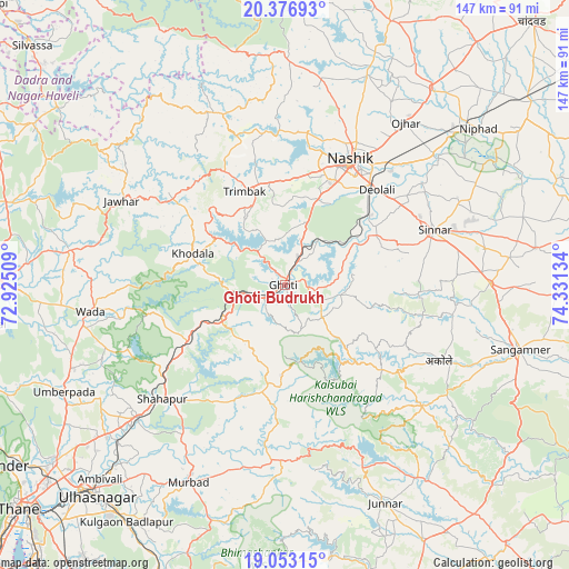
Ghoti Budrukh GPS coordinates[2]
19° 42' 59.076" North, 73° 37' 41.556" East
| Map corner | latitude | longitude |
|---|---|---|
| Upper-left | 20.37693°, | 72.92509° |
| Center: | 19.71641°, | 73.62821° |
| Lower-right: | 19.05315°, | 74.33134° |
| Map W x H: | 147.2×147.2 km | = 91.5×91.5mi |
| max Lat: | 34.9274° ⇑66.2% North |
| Ghoti Budrukh: | 19.71641° |
| min Lat: | ⇓33.8% South 8.09008° |
| min Long | Ghoti Budrukh | max Long |
| 68.82655° | 73.62821° | 96.81° |
| W 7.9%⇐ | ⇒92.1% E |
Elevation
Elevation of Ghoti Budrukh is 593 m = 1946 ft, and this is 297.4 m = 976 ft above average elevation for this country.
| Max E: |
3681 m = 12077 ft | 11.8% |
| Ghoti Budrukh | 593 m 1946 ft | |
| Avg. | 295.6 m = 970 ft | |
Min E: |
1 m = 3 ft | 88.2% |
See also: India elevation on elevation.city.
Geographical zone
Ghoti Budrukh is located in North Torrid zone (between Equator and Tropic of Cancer). Distance of this Northern Tropic circle is 413.7 km =257.1 mi to North.| Distance of | km | miles | from Ghoti Budrukh |
|---|---|---|---|
| North Pole | 7814.8 | 4855.9 | to North |
| Arctic Circle | 5208.9 | 3236.7 | to North |
| Tropic Cancer | 413.7 | 257.1 | to North |
| Equator | 2192.3 | 1362.2 | to South |


Nearby cities:
15 places around Ghoti Budrukh: (largest is in red/bold)
• Badlapur
73.1 km =45.4 mi,  211°
211°
• Deolāli
33.3 km =20.7 mi,  40°
40°
• Igatpuri
7.3 km =4.5 mi,  251°
251°
• Jawhār
47.3 km =29.4 mi,  297°
297°
• Junnar
62.2 km =38.6 mi,  155°
155°
• Kalyān
73.7 km =45.8 mi,  224°
224°
• Murbād
57.2 km =35.5 mi, 205°
• Nashik
35.6 km =22.1 mi,  28°
28°
• Ozar
52.5 km =32.6 mi, 36°
• Sangamner
63.3 km =39.3 mi,  105°
105°
• Shāhāpur
43.2 km =26.8 mi,  227°
227°
• Sinnar
41.3 km =25.7 mi,  69°
69°
• Trimbak
26.2 km =16.3 mi,  336°
336°
• Vasind
51.4 km =31.9 mi, 228°
• Vāda
50.7 km =31.5 mi,  262°
262°
Sources, notices
• [Note1] Compared only with cities in India existing in our database
• [Src1] Map data: © OpenStreetMap contributors (CC-BY-SA)
• [Src2] Other city data from geonames.org with taken over terms of usage.
• [Src3] Geographical zone / Annual Mean Temperature by Robert A. Rohde @ Wikipedia
