Jawhār geodata
Jawhār (Maharashtra) is a populated place; located in India in Asia/Kolkata (GMT+5.5) time zone. With population of 12,082 people, there are 2730 cities with bigger population in this country. Compared to other cities in India, 65.6% of cities are located further ↑North; 93.6% of cities are located further →East and 80.1% of cities have lower elevation than Jawhār. Note1


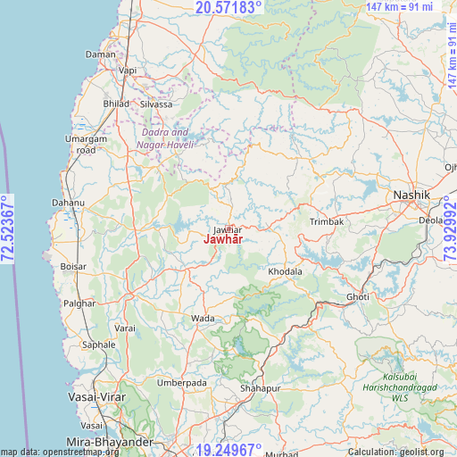
Jawhār GPS coordinates[2]
19° 54' 43.668" North, 73° 13' 36.444" East
| Map corner | latitude | longitude |
|---|---|---|
| Upper-left | 20.57183°, | 72.52367° |
| Center: | 19.91213°, | 73.22679° |
| Lower-right: | 19.24967°, | 73.92992° |
| Map W x H: | 147×147 km | = 91.3×91.3mi |
| max Lat: | 34.9274° ⇑65.6% North |
| Jawhār: | 19.91213° |
| min Lat: | ⇓34.4% South 8.09008° |
| min Long | Jawhār | max Long |
| 68.82655° | 73.22679° | 96.81° |
| W 6.4%⇐ | ⇒93.6% E |
Elevation
Elevation of Jawhār is 462 m = 1516 ft, and this is 166.4 m = 546 ft above average elevation for this country.
| Max E: |
3681 m = 12077 ft | 19.9% |
| Jawhār | 462 m 1516 ft | |
| Avg. | 295.6 m = 970 ft | |
Min E: |
1 m = 3 ft | 80.1% |
See also: India elevation on elevation.city.
Geographical zone
Jawhār is located in North Torrid zone (between Equator and Tropic of Cancer). Distance of this Northern Tropic circle is 391.9 km =243.5 mi to North.| Distance of | km | miles | from Jawhār |
|---|---|---|---|
| North Pole | 7793 | 4842.3 | to North |
| Arctic Circle | 5187.2 | 3223.2 | to North |
| Tropic Cancer | 391.9 | 243.5 | to North |
| Equator | 2214 | 1375.7 | to South |


Nearby cities:
15 places around Jawhār: (largest is in red/bold)
• Boisar
50.7 km =31.5 mi,  256°
256°
• Chinchani
56.8 km =35.3 mi,  265°
265°
• Dadra
53.4 km =33.2 mi,  329°
329°
• Dāhānu
54.1 km =33.6 mi,  276°
276°
• Ghoti Budrukh
47.3 km =29.4 mi,  117°
117°
• Igatpuri
42.6 km =26.5 mi, 124°
• Manor
39.2 km =24.4 mi,  237°
237°
• Pālghar
53.9 km =33.5 mi, 243°
• Shāhāpur
52.2 km =32.4 mi,  168°
168°
• Silvassa
46.8 km =29.1 mi, 329°
• Trimbak
31.7 km =19.7 mi,  85°
85°
• Tārāpur
57 km =35.4 mi, 264°
• Vasind
56.1 km =34.9 mi,  176°
176°
• Vāda
29.9 km =18.6 mi,  195°
195°
• Āmli
46.7 km =29 mi, 332°
Sources, notices
• [Note1] Compared only with cities in India existing in our database
• [Src1] Map data: © OpenStreetMap contributors (CC-BY-SA)
• [Src2] Other city data from geonames.org with taken over terms of usage.
• [Src3] Geographical zone / Annual Mean Temperature by Robert A. Rohde @ Wikipedia
