Igatpuri geodata
Igatpuri (Maharashtra) is a populated place; located in India in Asia/Kolkata (GMT+5.5) time zone. With population of 35,461 people, there are 1223 cities with bigger population in this country. Compared to other cities in India, 66.3% of cities are located further ↑North; 92.3% of cities are located further →East and 87.8% of cities have lower elevation than Igatpuri. Note1


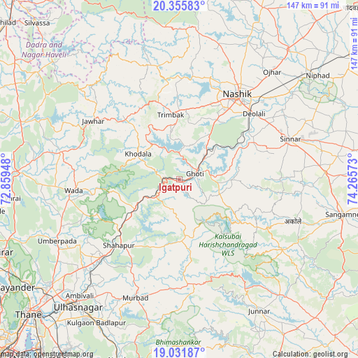
Igatpuri GPS coordinates[2]
19° 41' 42.792" North, 73° 33' 45.36" East
| Map corner | latitude | longitude |
|---|---|---|
| Upper-left | 20.35583°, | 72.85948° |
| Center: | 19.69522°, | 73.5626° |
| Lower-right: | 19.03187°, | 74.26573° |
| Map W x H: | 147.2×147.2 km | = 91.5×91.5mi |
| max Lat: | 34.9274° ⇑66.3% North |
| Igatpuri: | 19.69522° |
| min Lat: | ⇓33.7% South 8.09008° |
| min Long | Igatpuri | max Long |
| 68.82655° | 73.5626° | 96.81° |
| W 7.7%⇐ | ⇒92.3% E |
Elevation
Elevation of Igatpuri is 590 m = 1936 ft, and this is 294.4 m = 966 ft above average elevation for this country.
| Max E: |
3681 m = 12077 ft | 12.2% |
| Igatpuri | 590 m 1936 ft | |
| Avg. | 295.6 m = 970 ft | |
Min E: |
1 m = 3 ft | 87.8% |
See also: India elevation on elevation.city.
Geographical zone
Igatpuri is located in North Torrid zone (between Equator and Tropic of Cancer). Distance of this Northern Tropic circle is 416 km =258.5 mi to North.| Distance of | km | miles | from Igatpuri |
|---|---|---|---|
| North Pole | 7817.2 | 4857.4 | to North |
| Arctic Circle | 5211.3 | 3238.2 | to North |
| Tropic Cancer | 416 | 258.5 | to North |
| Equator | 2189.9 | 1360.7 | to South |


Nearby cities:
15 places around Igatpuri: (largest is in red/bold)
• Badlapur
67.6 km =42 mi,  207°
207°
• Deolāli
39.7 km =24.7 mi,  45°
45°
• Ghoti Budrukh
7.3 km =4.5 mi,  71°
71°
• Jawhār
42.6 km =26.5 mi,  304°
304°
• Junnar
63.3 km =39.3 mi,  148°
148°
• Kalyān
67.3 km =41.8 mi,  221°
221°
• Manor
68.4 km =42.5 mi,  272°
272°
• Murbād
52.3 km =32.5 mi,  200°
200°
• Nashik
41.2 km =25.6 mi,  35°
35°
• Ozar
58.6 km =36.4 mi, 40°
• Shāhāpur
36.7 km =22.8 mi, 222°
• Sinnar
48.6 km =30.2 mi, 69°
• Trimbak
26.6 km =16.5 mi,  352°
352°
• Vasind
44.8 km =27.8 mi, 224°
• Vāda
43.6 km =27.1 mi,  263°
263°
Sources, notices
• [Note1] Compared only with cities in India existing in our database
• [Src1] Map data: © OpenStreetMap contributors (CC-BY-SA)
• [Src2] Other city data from geonames.org with taken over terms of usage.
• [Src3] Geographical zone / Annual Mean Temperature by Robert A. Rohde @ Wikipedia
