Sapatgrām geodata
Sapatgrām (Assam) is a populated place; located in India in Asia/Kolkata (GMT+5.5) time zone. With population of 11,714 people, there are 2762 cities with bigger population in this country. Compared to other cities in India, 73.3% of cities are located further ↓South; 95.7% of cities are located further ←West and 81.4% of cities have higher elevation than Sapatgrām. Note1


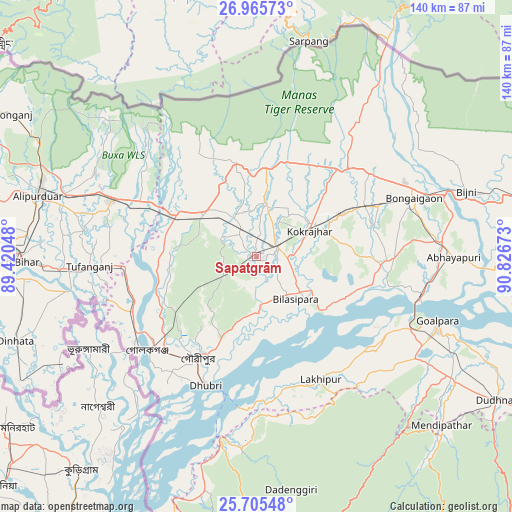
Sapatgrām GPS coordinates[2]
26° 20' 14.352" North, 90° 7' 24.96" East
| Map corner | latitude | longitude |
|---|---|---|
| Upper-left | 26.96573°, | 89.42048° |
| Center: | 26.33732°, | 90.1236° |
| Lower-right: | 25.70548°, | 90.82673° |
| Map W x H: | 140.1×140.1 km | = 87.1×87.1mi |
| max Lat: | 34.9274° ⇑26.7% North |
| Sapatgrām: | 26.33732° |
| min Lat: | ⇓73.3% South 8.09008° |
| min Long | Sapatgrām | max Long |
| 68.82655° | 90.1236° | 96.81° |
| W 95.7%⇐ | ⇒4.3% E |
Elevation
Elevation of Sapatgrām is 43 m = 141 ft, and this is 252.6 m = 829 ft below average elevation for this country.
| Max E: |
3681 m = 12077 ft | 81.4% |
| Avg. | 295.6 m = 970 ft | |
| Sapatgrām | 43 m = 141 ft | |
Min E: |
1 m = 3 ft | 18.6% |
See also: India elevation on elevation.city.
Geographical zone
Sapatgrām is located in North temperate zone (between Tropic of Cancer and the Arctic Circle). Distance of this Northern Tropic circle is 322.5 km =200.4 mi to South.| Distance of | km | miles | from Sapatgrām |
|---|---|---|---|
| North Pole | 7078.6 | 4398.4 | to North |
| Arctic Circle | 4472.7 | 2779.2 | to North |
| Tropic Cancer | 322.5 | 200.4 | to South |
| Equator | 2928.4 | 1819.6 | to South |


Nearby cities:
15 places around Sapatgrām: (largest is in red/bold)
• Abhayāpuri
56 km =34.8 mi,  91°
91°
• Bilāsipāra
16 km =9.9 mi,  136°
136°
• Bongaigaon
46 km =28.6 mi,  70°
70°
• Bāsugaon
32.8 km =20.4 mi,  63°
63°
• Chāpar
32.9 km =20.4 mi,  102°
102°
• Dhuburi
38 km =23.6 mi,  201°
201°
• Gauripur
32.6 km =20.3 mi,  209°
209°
• Golakganj
39.8 km =24.7 mi,  228°
228°
• Goshaingaon
19.6 km =12.2 mi,  305°
305°
• Goālpāra
53.2 km =33.1 mi,  109°
109°
• Jogīghopa
46.4 km =28.8 mi, 105°
• Kokrajhar
16.5 km =10.3 mi, 64°
• Lakhipur
38.7 km =24 mi,  151°
151°
• Latabāri
26.8 km =16.7 mi,  262°
262°
• Tufānganj
45.7 km =28.4 mi,  267°
267°
Sources, notices
• [Note1] Compared only with cities in India existing in our database
• [Src1] Map data: © OpenStreetMap contributors (CC-BY-SA)
• [Src2] Other city data from geonames.org with taken over terms of usage.
• [Src3] Geographical zone / Annual Mean Temperature by Robert A. Rohde @ Wikipedia
