Tufānganj geodata
Tufānganj (West Bengal) is a populated place; located in India in Asia/Kolkata (GMT+5.5) time zone. With population of 20,420 people, there are 2008 cities with bigger population in this country. Compared to other cities in India, 73.2% of cities are located further ↓South; 95.4% of cities are located further ←West and 81.9% of cities have higher elevation than Tufānganj. Note1


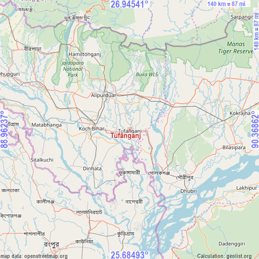
Tufānganj GPS coordinates[2]
26° 19' 0.768" North, 89° 39' 55.764" East
| Map corner | latitude | longitude |
|---|---|---|
| Upper-left | 26.94541°, | 88.96237° |
| Center: | 26.31688°, | 89.66549° |
| Lower-right: | 25.68493°, | 90.36862° |
| Map W x H: | 140.2×140.2 km | = 87.1×87.1mi |
| max Lat: | 34.9274° ⇑26.8% North |
| Tufānganj: | 26.31688° |
| min Lat: | ⇓73.2% South 8.09008° |
| min Long | Tufānganj | max Long |
| 68.82655° | 89.66549° | 96.81° |
| W 95.4%⇐ | ⇒4.6% E |
Elevation
Elevation of Tufānganj is 41 m = 135 ft, and this is 254.6 m = 835 ft below average elevation for this country.
| Max E: |
3681 m = 12077 ft | 81.9% |
| Avg. | 295.6 m = 970 ft | |
| Tufānganj | 41 m = 135 ft | |
Min E: |
1 m = 3 ft | 18.1% |
See also: India elevation on elevation.city.
Geographical zone
Tufānganj is located in North temperate zone (between Tropic of Cancer and the Arctic Circle). Distance of this Northern Tropic circle is 320.2 km =199 mi to South.| Distance of | km | miles | from Tufānganj |
|---|---|---|---|
| North Pole | 7080.9 | 4399.9 | to North |
| Arctic Circle | 4475 | 2780.6 | to North |
| Tropic Cancer | 320.2 | 199 | to South |
| Equator | 2926.2 | 1818.3 | to South |


Nearby cities:
15 places around Tufānganj: (largest is in red/bold)
• Alīpur Duār
23.3 km =14.5 mi,  322°
322°
• Bilāsipāra
57.5 km =35.7 mi,  99°
99°
• Dhuburi
46.1 km =28.6 mi,  136°
136°
• Dīnhāta
28.7 km =17.8 mi,  225°
225°
• Fālākāta
51.2 km =31.8 mi,  296°
296°
• Gauripur
39.3 km =24.4 mi,  131°
131°
• Golakganj
28.6 km =17.8 mi,  146°
146°
• Goshaingaon
32.6 km =20.3 mi,  65°
65°
• Hāsimāra
57 km =35.4 mi,  327°
327°
• Jaigaon
65.7 km =40.8 mi, 333°
• Koch Bihār
22 km =13.7 mi,  272°
272°
• Kokrajhar
61.2 km =38 mi,  81°
81°
• Latabāri
19.2 km =11.9 mi,  93°
93°
• Mātābhānga
44.9 km =27.9 mi, 273°
• Sapatgrām
45.7 km =28.4 mi, 87°
Sources, notices
• [Note1] Compared only with cities in India existing in our database
• [Src1] Map data: © OpenStreetMap contributors (CC-BY-SA)
• [Src2] Other city data from geonames.org with taken over terms of usage.
• [Src3] Geographical zone / Annual Mean Temperature by Robert A. Rohde @ Wikipedia
