Sachīn geodata
Sachīn (Gujarat) is a populated place; located in India in Asia/Kolkata (GMT+5.5) time zone. With population of 12,662 people, there are 2685 cities with bigger population in this country. Compared to other cities in India, 61.3% of cities are located further ↑North; 95.5% of cities are located further →East and 91.1% of cities have higher elevation than Sachīn. Note1


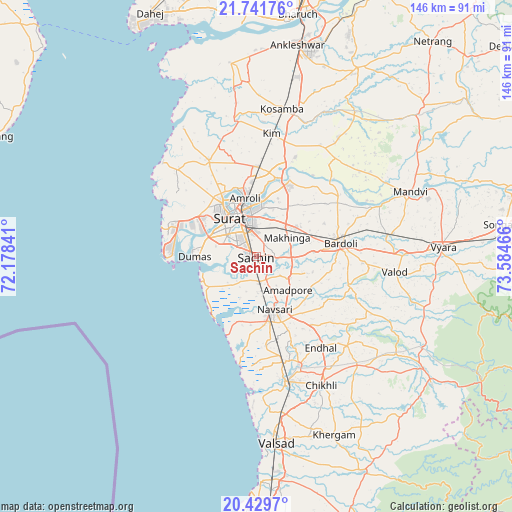
Sachīn GPS coordinates[2]
21° 5' 13.848" North, 72° 52' 53.508" East
| Map corner | latitude | longitude |
|---|---|---|
| Upper-left | 21.74176°, | 72.17841° |
| Center: | 21.08718°, | 72.88153° |
| Lower-right: | 20.4297°, | 73.58466° |
| Map W x H: | 145.9×145.9 km | = 90.7×90.7mi |
| max Lat: | 34.9274° ⇑61.3% North |
| Sachīn: | 21.08718° |
| min Lat: | ⇓38.7% South 8.09008° |
| min Long | Sachīn | max Long |
| 68.82655° | 72.88153° | 96.81° |
| W 4.5%⇐ | ⇒95.5% E |
Elevation
Elevation of Sachīn is 16 m = 52 ft, and this is 279.6 m = 917 ft below average elevation for this country.
| Max E: |
3681 m = 12077 ft | 91.1% |
| Avg. | 295.6 m = 970 ft | |
| Sachīn | 16 m = 52 ft | |
Min E: |
1 m = 3 ft | 8.9% |
See also: India elevation on elevation.city.
Geographical zone
Sachīn is located in North Torrid zone (between Equator and Tropic of Cancer). Distance of this Northern Tropic circle is 261.2 km =162.3 mi to North.| Distance of | km | miles | from Sachīn |
|---|---|---|---|
| North Pole | 7662.4 | 4761.2 | to North |
| Arctic Circle | 5056.5 | 3142 | to North |
| Tropic Cancer | 261.2 | 162.3 | to North |
| Equator | 2344.7 | 1456.9 | to South |


Nearby cities:
15 places around Sachīn: (largest is in red/bold)
• Abrama
25.5 km =15.8 mi,  174°
174°
• Amroli
18.7 km =11.6 mi,  346°
346°
• Bilimora
36.3 km =22.6 mi, 166°
• Bārdoli
24.2 km =15 mi,  80°
80°
• Chikhli
41.2 km =25.6 mi,  152°
152°
• Gandevi
32.9 km =20.4 mi,  158°
158°
• Jalālpur
15.5 km =9.6 mi, 173°
• Kadod
37.9 km =23.5 mi,  67°
67°
• Kosamba
42.4 km =26.3 mi,  10°
10°
• Kāthor
23.2 km =14.4 mi,  15°
15°
• Māndvi
47.6 km =29.6 mi, 66°
• Navsāri
16.7 km =10.4 mi, 164°
• Olpād
30.8 km =19.1 mi,  334°
334°
• Sūrat
13.2 km =8.2 mi,  336°
336°
• Utrān
16.3 km =10.1 mi, 354°
Sources, notices
• [Note1] Compared only with cities in India existing in our database
• [Src1] Map data: © OpenStreetMap contributors (CC-BY-SA)
• [Src2] Other city data from geonames.org with taken over terms of usage.
• [Src3] Geographical zone / Annual Mean Temperature by Robert A. Rohde @ Wikipedia
