Māndvi geodata
Māndvi (Gujarat) is a populated place; located in India in Asia/Kolkata (GMT+5.5) time zone. With population of 18,669 people, there are 2156 cities with bigger population in this country. Compared to other cities in India, 60.3% of cities are located further ↑North; 93.4% of cities are located further →East and 80.7% of cities have higher elevation than Māndvi. Note1


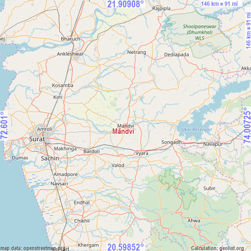
Māndvi GPS coordinates[2]
21° 15' 18.936" North, 73° 18' 14.832" East
| Map corner | latitude | longitude |
|---|---|---|
| Upper-left | 21.90908°, | 72.601° |
| Center: | 21.25526°, | 73.30412° |
| Lower-right: | 20.59852°, | 74.00725° |
| Map W x H: | 145.7×145.7 km | = 90.5×90.5mi |
| max Lat: | 34.9274° ⇑60.3% North |
| Māndvi: | 21.25526° |
| min Lat: | ⇓39.7% South 8.09008° |
| min Long | Māndvi | max Long |
| 68.82655° | 73.30412° | 96.81° |
| W 6.6%⇐ | ⇒93.4% E |
Elevation
Elevation of Māndvi is 45 m = 148 ft, and this is 250.6 m = 822 ft below average elevation for this country.
| Max E: |
3681 m = 12077 ft | 80.7% |
| Avg. | 295.6 m = 970 ft | |
| Māndvi | 45 m = 148 ft | |
Min E: |
1 m = 3 ft | 19.3% |
See also: India elevation on elevation.city.
Geographical zone
Māndvi is located in North Torrid zone (between Equator and Tropic of Cancer). Distance of this Northern Tropic circle is 242.6 km =150.7 mi to North.| Distance of | km | miles | from Māndvi |
|---|---|---|---|
| North Pole | 7643.7 | 4749.6 | to North |
| Arctic Circle | 5037.8 | 3130.3 | to North |
| Tropic Cancer | 242.6 | 150.7 | to North |
| Equator | 2363.4 | 1468.5 | to South |


Nearby cities:
15 places around Māndvi: (largest is in red/bold)
• Amroli
48.2 km =30 mi,  269°
269°
• Ankleshwar
53.1 km =33 mi,  322°
322°
• Bārdoli
24.8 km =15.4 mi,  233°
233°
• Jalālpur
54.1 km =33.6 mi, 231°
• Kadod
9.7 km =6 mi,  244°
244°
• Kosamba
42.5 km =26.4 mi,  302°
302°
• Kāthor
37.8 km =23.5 mi,  275°
275°
• Navsāri
52.5 km =32.6 mi, 228°
• Sachīn
47.6 km =29.6 mi,  246°
246°
• Songadh
28.5 km =17.7 mi,  109°
109°
• Sūrat
49.6 km =30.8 mi,  262°
262°
• Utrān
45.4 km =28.2 mi, 266°
• Vyāra
18.6 km =11.6 mi,  149°
149°
• Vānsada
55.6 km =34.5 mi,  173°
173°
• Waghāi
57.6 km =35.8 mi,  159°
159°
Sources, notices
• [Note1] Compared only with cities in India existing in our database
• [Src1] Map data: © OpenStreetMap contributors (CC-BY-SA)
• [Src2] Other city data from geonames.org with taken over terms of usage.
• [Src3] Geographical zone / Annual Mean Temperature by Robert A. Rohde @ Wikipedia
