Bilimora geodata
Bilimora (Gujarat) is a populated place; located in India in Asia/Kolkata (GMT+5.5) time zone. With population of 510,879 people, there are 88 cities with bigger population in this country. Compared to other cities in India, 62.7% of cities are located further ↑North; 94.9% of cities are located further →East and 91.9% of cities have higher elevation than Bilimora. Note1


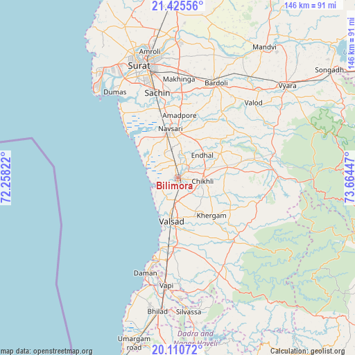
Bilimora GPS coordinates[2]
20° 46' 10.452" North, 72° 57' 40.824" East
| Map corner | latitude | longitude |
|---|---|---|
| Upper-left | 21.42556°, | 72.25822° |
| Center: | 20.76957°, | 72.96134° |
| Lower-right: | 20.11072°, | 73.66447° |
| Map W x H: | 146.2×146.2 km | = 90.8×90.8mi |
| max Lat: | 34.9274° ⇑62.7% North |
| Bilimora: | 20.76957° |
| min Lat: | ⇓37.3% South 8.09008° |
| min Long | Bilimora | max Long |
| 68.82655° | 72.96134° | 96.81° |
| W 5.1%⇐ | ⇒94.9% E |
Elevation
Elevation of Bilimora is 15 m = 49 ft, and this is 280.6 m = 921 ft below average elevation for this country.
| Max E: |
3681 m = 12077 ft | 91.9% |
| Avg. | 295.6 m = 970 ft | |
| Bilimora | 15 m = 49 ft | |
Min E: |
1 m = 3 ft | 8.1% |
See also: Bilimora elevation on elevation.city.
Geographical zone
Bilimora is located in North Torrid zone (between Equator and Tropic of Cancer). Distance of this Northern Tropic circle is 296.6 km =184.3 mi to North.| Distance of | km | miles | from Bilimora |
|---|---|---|---|
| North Pole | 7697.7 | 4783.1 | to North |
| Arctic Circle | 5091.8 | 3163.9 | to North |
| Tropic Cancer | 296.6 | 184.3 | to North |
| Equator | 2309.4 | 1435 | to South |


Nearby cities:
15 places around Bilimora: (largest is in red/bold)
• Abrama
11.4 km =7.1 mi,  330°
330°
• Bārdoli
42.3 km =26.3 mi,  21°
21°
• Chikhli
10.6 km =6.6 mi,  97°
97°
• Daman
41.7 km =25.9 mi,  198°
198°
• Dharampur
34 km =21.1 mi,  139°
139°
• Gandevi
6.1 km =3.8 mi,  38°
38°
• Jalālpur
21 km =13 mi,  341°
341°
• Navsāri
19.6 km =12.2 mi,  348°
348°
• Parnera
23.2 km =14.4 mi,  183°
183°
• Pārdi
29.1 km =18.1 mi, 183°
• Sachīn
36.3 km =22.6 mi, 346°
• Sūrat
49.3 km =30.6 mi, 343°
• Valsād
18 km =11.2 mi,  189°
189°
• Vapi
44.6 km =27.7 mi, 187°
• Vānsada
41.9 km =26 mi,  91°
91°
Sources, notices
• [Note1] Compared only with cities in India existing in our database
• [Src1] Map data: © OpenStreetMap contributors (CC-BY-SA)
• [Src2] Other city data from geonames.org with taken over terms of usage.
• [Src3] Geographical zone / Annual Mean Temperature by Robert A. Rohde @ Wikipedia
