Jalālpur geodata
Jalālpur (Gujarat) is a populated place; located in India in Asia/Kolkata (GMT+5.5) time zone. With population of 17,325 people, there are 2256 cities with bigger population in this country. Compared to other cities in India, 61.8% of cities are located further ↑North; 95.4% of cities are located further →East and 92.8% of cities have higher elevation than Jalālpur. Note1


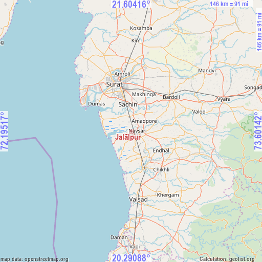
Jalālpur GPS coordinates[2]
20° 56' 56.256" North, 72° 53' 53.844" East
| Map corner | latitude | longitude |
|---|---|---|
| Upper-left | 21.60416°, | 72.19517° |
| Center: | 20.94896°, | 72.89829° |
| Lower-right: | 20.29088°, | 73.60142° |
| Map W x H: | 146×146 km | = 90.7×90.7mi |
| max Lat: | 34.9274° ⇑61.8% North |
| Jalālpur: | 20.94896° |
| min Lat: | ⇓38.2% South 8.09008° |
| min Long | Jalālpur | max Long |
| 68.82655° | 72.89829° | 96.81° |
| W 4.6%⇐ | ⇒95.4% E |
Elevation
Elevation of Jalālpur is 14 m = 46 ft, and this is 281.6 m = 924 ft below average elevation for this country.
| Max E: |
3681 m = 12077 ft | 92.8% |
| Avg. | 295.6 m = 970 ft | |
| Jalālpur | 14 m = 46 ft | |
Min E: |
1 m = 3 ft | 7.2% |
See also: India elevation on elevation.city.
Geographical zone
Jalālpur is located in North Torrid zone (between Equator and Tropic of Cancer). Distance of this Northern Tropic circle is 276.6 km =171.9 mi to North.| Distance of | km | miles | from Jalālpur |
|---|---|---|---|
| North Pole | 7677.8 | 4770.8 | to North |
| Arctic Circle | 5071.9 | 3151.5 | to North |
| Tropic Cancer | 276.6 | 171.9 | to North |
| Equator | 2329.3 | 1447.4 | to South |


Nearby cities:
15 places around Jalālpur: (largest is in red/bold)
• Abrama
10.1 km =6.3 mi,  175°
175°
• Amroli
34.1 km =21.2 mi,  349°
349°
• Bilimora
21 km =13 mi,  161°
161°
• Bārdoli
29.4 km =18.3 mi,  48°
48°
• Chikhli
27.3 km =17 mi,  141°
141°
• Gandevi
18.4 km =11.4 mi,  145°
145°
• Kadod
44.7 km =27.8 mi, 48°
• Kāthor
38 km =23.6 mi,  6°
6°
• Navsāri
2.8 km =1.7 mi,  104°
104°
• Olpād
45.7 km =28.4 mi,  340°
340°
• Parnera
43.5 km =27 mi,  173°
173°
• Sachīn
15.5 km =9.6 mi, 353°
• Sūrat
28.4 km =17.6 mi, 345°
• Utrān
31.8 km =19.8 mi, 354°
• Valsād
37.9 km =23.5 mi, 174°
Sources, notices
• [Note1] Compared only with cities in India existing in our database
• [Src1] Map data: © OpenStreetMap contributors (CC-BY-SA)
• [Src2] Other city data from geonames.org with taken over terms of usage.
• [Src3] Geographical zone / Annual Mean Temperature by Robert A. Rohde @ Wikipedia
