Olpād geodata
Olpād (Gujarat) is a populated place; located in India in Asia/Kolkata (GMT+5.5) time zone. With population of 14,091 people, there are 2554 cities with bigger population in this country. Compared to other cities in India, 59.8% of cities are located further ↑North; 96.2% of cities are located further →East and 96.4% of cities have higher elevation than Olpād. Note1


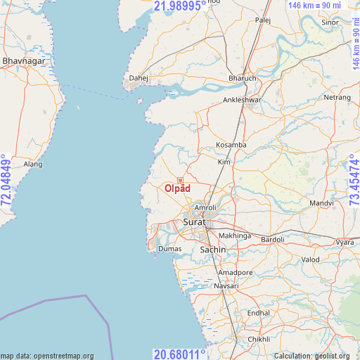
Olpād GPS coordinates[2]
21° 20' 11.364" North, 72° 45' 5.796" East
| Map corner | latitude | longitude |
|---|---|---|
| Upper-left | 21.98995°, | 72.04849° |
| Center: | 21.33649°, | 72.75161° |
| Lower-right: | 20.68011°, | 73.45474° |
| Map W x H: | 145.6×145.6 km | = 90.5×90.5mi |
| max Lat: | 34.9274° ⇑59.8% North |
| Olpād: | 21.33649° |
| min Lat: | ⇓40.2% South 8.09008° |
| min Long | Olpād | max Long |
| 68.82655° | 72.75161° | 96.81° |
| W 3.8%⇐ | ⇒96.2% E |
Elevation
Elevation of Olpād is 10 m = 33 ft, and this is 285.6 m = 937 ft below average elevation for this country.
| Max E: |
3681 m = 12077 ft | 96.4% |
| Avg. | 295.6 m = 970 ft | |
| Olpād | 10 m = 33 ft | |
Min E: |
1 m = 3 ft | 3.6% |
See also: India elevation on elevation.city.
Geographical zone
Olpād is located in North Torrid zone (between Equator and Tropic of Cancer). Distance of this Northern Tropic circle is 233.5 km =145.1 mi to North.| Distance of | km | miles | from Olpād |
|---|---|---|---|
| North Pole | 7634.7 | 4744 | to North |
| Arctic Circle | 5028.8 | 3124.8 | to North |
| Tropic Cancer | 233.5 | 145.1 | to North |
| Equator | 2372.4 | 1474.1 | to South |


Nearby cities:
15 places around Olpād: (largest is in red/bold)
• Abrama
55.5 km =34.5 mi,  163°
163°
• Amroli
13.1 km =8.1 mi,  136°
136°
• Ankleshwar
41.1 km =25.5 mi,  36°
36°
• Bharūch
46.3 km =28.8 mi,  30°
30°
• Bārdoli
44.2 km =27.5 mi,  122°
122°
• Hansot
28.2 km =17.5 mi,  11°
11°
• Jalālpur
45.7 km =28.4 mi, 160°
• Kadod
50.3 km =31.3 mi,  105°
105°
• Kosamba
25.6 km =15.9 mi,  56°
56°
• Kāthor
20.3 km =12.6 mi, 105°
• Māndvi
57.9 km =36 mi,  98°
98°
• Navsāri
47.4 km =29.5 mi, 157°
• Sachīn
30.8 km =19.1 mi,  154°
154°
• Sūrat
17.6 km =10.9 mi, 152°
• Utrān
16.5 km =10.3 mi,  133°
133°
Sources, notices
• [Note1] Compared only with cities in India existing in our database
• [Src1] Map data: © OpenStreetMap contributors (CC-BY-SA)
• [Src2] Other city data from geonames.org with taken over terms of usage.
• [Src3] Geographical zone / Annual Mean Temperature by Robert A. Rohde @ Wikipedia
