Mangan geodata
Mangan (Sikkim) is a populated place; located in India in Asia/Kolkata (GMT+5.5) time zone. With population of 1,464 people, there are 3450 cities with bigger population in this country. Compared to other cities in India, 81.9% of cities are located further ↓South; 94.4% of cities are located further ←West and 95.8% of cities have lower elevation than Mangan. Note1


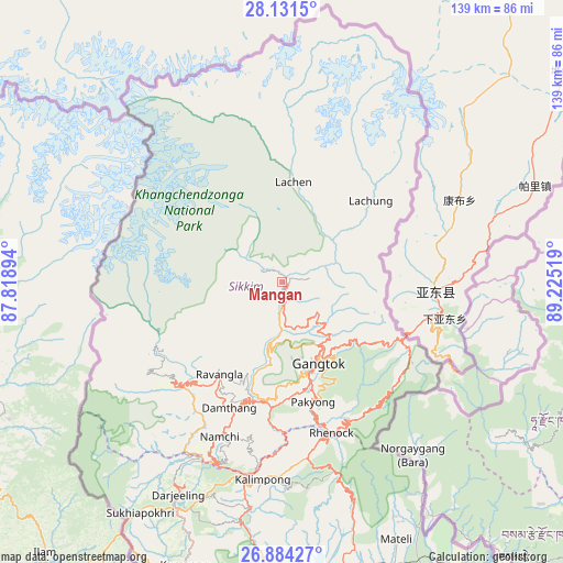
Mangan GPS coordinates[2]
27° 30' 34.74" North, 88° 31' 19.416" East
| Map corner | latitude | longitude |
|---|---|---|
| Upper-left | 28.1315°, | 87.81894° |
| Center: | 27.50965°, | 88.52206° |
| Lower-right: | 26.88427°, | 89.22519° |
| Map W x H: | 138.7×138.7 km | = 86.2×86.2mi |
| max Lat: | 34.9274° ⇑18.1% North |
| Mangan: | 27.50965° |
| min Lat: | ⇓81.9% South 8.09008° |
| min Long | Mangan | max Long |
| 68.82655° | 88.52206° | 96.81° |
| W 94.4%⇐ | ⇒5.6% E |
Elevation
Elevation of Mangan is 953 m = 3127 ft, and this is 657.4 m = 2157 ft above average elevation for this country.
| Max E: |
3681 m = 12077 ft | 4.2% |
| Mangan | 953 m 3127 ft | |
| Avg. | 295.6 m = 970 ft | |
Min E: |
1 m = 3 ft | 95.8% |
See also: India elevation on elevation.city.
Geographical zone
Mangan is located in North temperate zone (between Tropic of Cancer and the Arctic Circle). Distance of this Northern Tropic circle is 452.9 km =281.4 mi to South.| Distance of | km | miles | from Mangan |
|---|---|---|---|
| North Pole | 6948.3 | 4317.5 | to North |
| Arctic Circle | 4342.4 | 2698.2 | to North |
| Tropic Cancer | 452.9 | 281.4 | to South |
| Equator | 3058.8 | 1900.6 | to South |


Nearby cities:
15 places around Mangan: (largest is in red/bold)
• Bagdogra
92.5 km =57.5 mi,  193°
193°
• Dārjiling
58.7 km =36.5 mi,  205°
205°
• Gangtok
22.3 km =13.9 mi,  156°
156°
• Gyalshing
35.8 km =22.2 mi,  226°
226°
• Jorethang
48.9 km =30.4 mi,  203°
203°
• Kalimpong, Крукети
50.8 km =31.6 mi, 186°
• Kālimpong
49 km =30.4 mi, 185°
• Kārsiyāng
73.8 km =45.9 mi, 199°
• Mirik
76.5 km =47.5 mi, 205°
• Namchi
41.4 km =25.7 mi, 202°
• Naya Bāzār
50.5 km =31.4 mi, 213°
• Odlābāri
75.6 km =47 mi,  171°
171°
• Rangpo
37 km =23 mi,  178°
178°
• Siliguri
89.4 km =55.6 mi, 185°
• Singtam
30.6 km =19 mi, 183°
Sources, notices
• [Note1] Compared only with cities in India existing in our database
• [Src1] Map data: © OpenStreetMap contributors (CC-BY-SA)
• [Src2] Other city data from geonames.org with taken over terms of usage.
• [Src3] Geographical zone / Annual Mean Temperature by Robert A. Rohde @ Wikipedia
