Pālkonda geodata
Pālkonda (Andhra Pradesh) is a populated place; located in India in Asia/Kolkata (GMT+5.5) time zone. With population of 29,378 people, there are 1477 cities with bigger population in this country. Compared to other cities in India, 70.1% of cities are located further ↑North; 81.3% of cities are located further ←West and 78.9% of cities have higher elevation than Pālkonda. Note1


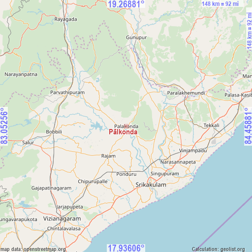
Pālkonda GPS coordinates[2]
18° 36' 13.464" North, 83° 45' 20.448" East
| Map corner | latitude | longitude |
|---|---|---|
| Upper-left | 19.26881°, | 83.05256° |
| Center: | 18.60374°, | 83.75568° |
| Lower-right: | 17.93606°, | 84.45881° |
| Map W x H: | 148.2×148.2 km | = 92.1×92.1mi |
| max Lat: | 34.9274° ⇑70.1% North |
| Pālkonda: | 18.60374° |
| min Lat: | ⇓29.9% South 8.09008° |
| min Long | Pālkonda | max Long |
| 68.82655° | 83.75568° | 96.81° |
| W 81.3%⇐ | ⇒18.7% E |
Elevation
Elevation of Pālkonda is 52 m = 171 ft, and this is 243.6 m = 799 ft below average elevation for this country.
| Max E: |
3681 m = 12077 ft | 78.9% |
| Avg. | 295.6 m = 970 ft | |
| Pālkonda | 52 m = 171 ft | |
Min E: |
1 m = 3 ft | 21.1% |
See also: India elevation on elevation.city.
Geographical zone
Pālkonda is located in North Torrid zone (between Equator and Tropic of Cancer). Distance of this Northern Tropic circle is 537.4 km =333.9 mi to North.| Distance of | km | miles | from Pālkonda |
|---|---|---|---|
| North Pole | 7938.5 | 4932.8 | to North |
| Arctic Circle | 5332.6 | 3313.5 | to North |
| Tropic Cancer | 537.4 | 333.9 | to North |
| Equator | 2068.5 | 1285.3 | to South |


Nearby cities:
15 places around Pālkonda: (largest is in red/bold)
• Amudālavalasa
26.5 km =16.5 mi,  144°
144°
• Bobbili
41.9 km =26 mi,  265°
265°
• Chīpurupalle
38 km =23.6 mi,  211°
211°
• Ganguvāda
38.7 km =24 mi,  79°
79°
• Gunupur
53.3 km =33.1 mi,  6°
6°
• Mandasa
80.1 km =49.8 mi,  68°
68°
• Narasannapeta
37 km =23 mi,  124°
124°
• Palāsa
71.4 km =44.4 mi, 74°
• Parlākimidi
40.2 km =25 mi,  60°
60°
• Pārvatipuram
40.1 km =24.9 mi,  299°
299°
• Rāzām
20 km =12.4 mi, 210°
• Srikakulam
37 km =23 mi,  156°
156°
• Sālūr
58.8 km =36.5 mi,  260°
260°
• Tekkali
50.6 km =31.4 mi,  89°
89°
• Vizianagaram
65.2 km =40.5 mi, 213°
Sources, notices
• [Note1] Compared only with cities in India existing in our database
• [Src1] Map data: © OpenStreetMap contributors (CC-BY-SA)
• [Src2] Other city data from geonames.org with taken over terms of usage.
• [Src3] Geographical zone / Annual Mean Temperature by Robert A. Rohde @ Wikipedia
