Sālūr geodata
Sālūr (Andhra Pradesh) is a populated place; located in India in Asia/Kolkata (GMT+5.5) time zone. With population of 50,206 people, there are 886 cities with bigger population in this country. Compared to other cities in India, 70.4% of cities are located further ↑North; 79.9% of cities are located further ←West and 57.6% of cities have higher elevation than Sālūr. Note1


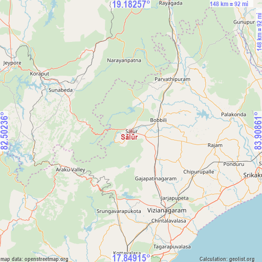
Sālūr GPS coordinates[2]
18° 31' 1.776" North, 83° 12' 19.728" East
| Map corner | latitude | longitude |
|---|---|---|
| Upper-left | 19.18257°, | 82.50236° |
| Center: | 18.51716°, | 83.20548° |
| Lower-right: | 17.84915°, | 83.90861° |
| Map W x H: | 148.3×148.3 km | = 92.1×92.1mi |
| max Lat: | 34.9274° ⇑70.4% North |
| Sālūr: | 18.51716° |
| min Lat: | ⇓29.6% South 8.09008° |
| min Long | Sālūr | max Long |
| 68.82655° | 83.20548° | 96.81° |
| W 79.9%⇐ | ⇒20.1% E |
Elevation
Elevation of Sālūr is 160 m = 525 ft, and this is 135.6 m = 445 ft below average elevation for this country.
| Max E: |
3681 m = 12077 ft | 57.6% |
| Avg. | 295.6 m = 970 ft | |
| Sālūr | 160 m = 525 ft | |
Min E: |
1 m = 3 ft | 42.4% |
See also: Sālūr elevation on elevation.city.
Geographical zone
Sālūr is located in North Torrid zone (between Equator and Tropic of Cancer). Distance of this Northern Tropic circle is 547 km =339.9 mi to North.| Distance of | km | miles | from Sālūr |
|---|---|---|---|
| North Pole | 7948.1 | 4938.7 | to North |
| Arctic Circle | 5342.3 | 3319.6 | to North |
| Tropic Cancer | 547 | 339.9 | to North |
| Equator | 2058.9 | 1279.3 | to South |


Nearby cities:
15 places around Sālūr: (largest is in red/bold)
• Amudālavalasa
74.5 km =46.3 mi,  99°
99°
• Bhīmunipatnam
74.4 km =46.2 mi,  159°
159°
• Bobbili
17.4 km =10.8 mi,  68°
68°
• Chodavaram
81.7 km =50.8 mi,  200°
200°
• Chīpurupalle
44.6 km =27.7 mi,  120°
120°
• Gunupur
89.2 km =55.4 mi,  45°
45°
• Jeypore
76.7 km =47.7 mi,  299°
299°
• Korāput
61.6 km =38.3 mi, 302°
• Mādugula
78.5 km =48.8 mi,  211°
211°
• Pālkonda
58.8 km =36.5 mi,  80°
80°
• Pārvatipuram
37.7 km =23.4 mi,  38°
38°
• Rāzām
48.5 km =30.1 mi, 98°
• Srikakulam
76.9 km =47.8 mi,  108°
108°
• Vepagunta
82.1 km =51 mi,  179°
179°
• Vizianagaram
49.5 km =30.8 mi,  153°
153°
Sources, notices
• [Note1] Compared only with cities in India existing in our database
• [Src1] Map data: © OpenStreetMap contributors (CC-BY-SA)
• [Src2] Other city data from geonames.org with taken over terms of usage.
• [Src3] Geographical zone / Annual Mean Temperature by Robert A. Rohde @ Wikipedia
