Rāzām geodata
Rāzām (Andhra Pradesh) is a populated place; located in India in Asia/Kolkata (GMT+5.5) time zone. With population of 27,832 people, there are 1549 cities with bigger population in this country. Compared to other cities in India, 70.5% of cities are located further ↑North; 81.1% of cities are located further ←West and 74.2% of cities have higher elevation than Rāzām. Note1


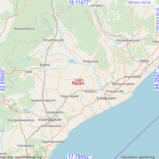
Rāzām GPS coordinates[2]
18° 26' 56.724" North, 83° 39' 34.452" East
| Map corner | latitude | longitude |
|---|---|---|
| Upper-left | 19.11477°, | 82.95645° |
| Center: | 18.44909°, | 83.65957° |
| Lower-right: | 17.78082°, | 84.3627° |
| Map W x H: | 148.3×148.3 km | = 92.1×92.1mi |
| max Lat: | 34.9274° ⇑70.5% North |
| Rāzām: | 18.44909° |
| min Lat: | ⇓29.5% South 8.09008° |
| min Long | Rāzām | max Long |
| 68.82655° | 83.65957° | 96.81° |
| W 81.1%⇐ | ⇒18.9% E |
Elevation
Elevation of Rāzām is 72 m = 236 ft, and this is 223.6 m = 734 ft below average elevation for this country.
| Max E: |
3681 m = 12077 ft | 74.2% |
| Avg. | 295.6 m = 970 ft | |
| Rāzām | 72 m = 236 ft | |
Min E: |
1 m = 3 ft | 25.8% |
See also: India elevation on elevation.city.
Geographical zone
Rāzām is located in North Torrid zone (between Equator and Tropic of Cancer). Distance of this Northern Tropic circle is 554.6 km =344.6 mi to North.| Distance of | km | miles | from Rāzām |
|---|---|---|---|
| North Pole | 7955.7 | 4943.4 | to North |
| Arctic Circle | 5349.8 | 3324.2 | to North |
| Tropic Cancer | 554.6 | 344.6 | to North |
| Equator | 2051.3 | 1274.6 | to South |


Nearby cities:
15 places around Rāzām: (largest is in red/bold)
• Amudālavalasa
26 km =16.2 mi,  99°
99°
• Bhīmunipatnam
65.9 km =40.9 mi,  199°
199°
• Bobbili
34.6 km =21.5 mi,  293°
293°
• Chīpurupalle
18.1 km =11.2 mi,  212°
212°
• Ganguvāda
53.9 km =33.5 mi,  63°
63°
• Gunupur
71.9 km =44.7 mi,  12°
12°
• Narasannapeta
40.8 km =25.4 mi, 95°
• Palāsa
86.9 km =54 mi,  65°
65°
• Parlākimidi
58.3 km =36.2 mi,  50°
50°
• Pālkonda
20 km =12.4 mi,  30°
30°
• Pārvatipuram
44.6 km =27.7 mi,  326°
326°
• Srikakulam
30.2 km =18.8 mi,  123°
123°
• Sālūr
48.5 km =30.1 mi,  278°
278°
• Tekkali
63.2 km =39.3 mi, 73°
• Vizianagaram
45.3 km =28.1 mi,  215°
215°
Sources, notices
• [Note1] Compared only with cities in India existing in our database
• [Src1] Map data: © OpenStreetMap contributors (CC-BY-SA)
• [Src2] Other city data from geonames.org with taken over terms of usage.
• [Src3] Geographical zone / Annual Mean Temperature by Robert A. Rohde @ Wikipedia
