Ganguvāda geodata
Ganguvāda (Andhra Pradesh) is a populated place; located in India in Asia/Kolkata (GMT+5.5) time zone. With population of 2,065 people, there are 3430 cities with bigger population in this country. Compared to other cities in India, 69.8% of cities are located further ↑North; 82.2% of cities are located further ←West and 53.6% of cities have lower elevation than Ganguvāda. Note1


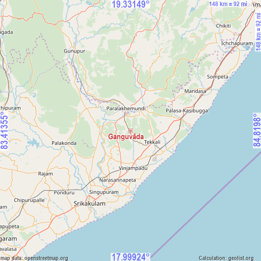
Ganguvāda GPS coordinates[2]
18° 40' 0.012" North, 84° 7' 0.012" East
| Map corner | latitude | longitude |
|---|---|---|
| Upper-left | 19.33149°, | 83.41355° |
| Center: | 18.66667°, | 84.11667° |
| Lower-right: | 17.99924°, | 84.8198° |
| Map W x H: | 148.1×148.1 km | = 92×92mi |
| max Lat: | 34.9274° ⇑69.8% North |
| Ganguvāda: | 18.66667° |
| min Lat: | ⇓30.2% South 8.09008° |
| min Long | Ganguvāda | max Long |
| 68.82655° | 84.11667° | 96.81° |
| W 82.2%⇐ | ⇒17.8% E |
Elevation
Elevation of Ganguvāda is 220 m = 722 ft, and this is 75.6 m = 248 ft below average elevation for this country.
| Max E: |
3681 m = 12077 ft | 46.4% |
| Avg. | 295.6 m = 970 ft | |
| Ganguvāda | 220 m = 722 ft | |
Min E: |
1 m = 3 ft | 53.6% |
See also: India elevation on elevation.city.
Geographical zone
Ganguvāda is located in North Torrid zone (between Equator and Tropic of Cancer). Distance of this Northern Tropic circle is 530.4 km =329.6 mi to North.| Distance of | km | miles | from Ganguvāda |
|---|---|---|---|
| North Pole | 7931.5 | 4928.4 | to North |
| Arctic Circle | 5325.6 | 3309.2 | to North |
| Tropic Cancer | 530.4 | 329.6 | to North |
| Equator | 2075.5 | 1289.7 | to South |


Nearby cities:
15 places around Ganguvāda: (largest is in red/bold)
• Amudālavalasa
36.3 km =22.6 mi,  218°
218°
• Chikitigarh
79.3 km =49.3 mi,  41°
41°
• Chīpurupalle
70 km =43.5 mi,  235°
235°
• Gunupur
56.3 km =35 mi,  324°
324°
• Ichchāpuram
77.9 km =48.4 mi,  50°
50°
• Mandasa
42.8 km =26.6 mi,  58°
58°
• Narasannapeta
29.1 km =18.1 mi,  195°
195°
• Palāsa
33.1 km =20.6 mi,  69°
69°
• Parlākimidi
13.1 km =8.1 mi,  346°
346°
• Pālkonda
38.7 km =24 mi,  259°
259°
• Pārvatipuram
73.9 km =45.9 mi,  280°
280°
• Rāzām
53.9 km =33.5 mi, 243°
• Sompeta
58.1 km =36.1 mi, 57°
• Srikakulam
47 km =29.2 mi,  209°
209°
• Tekkali
14.2 km =8.8 mi,  118°
118°
Sources, notices
• [Note1] Compared only with cities in India existing in our database
• [Src1] Map data: © OpenStreetMap contributors (CC-BY-SA)
• [Src2] Other city data from geonames.org with taken over terms of usage.
• [Src3] Geographical zone / Annual Mean Temperature by Robert A. Rohde @ Wikipedia
