Gunupur geodata
Gunupur (Odisha) is a populated place; located in India in Asia/Kolkata (GMT+5.5) time zone. With population of 22,264 people, there are 1887 cities with bigger population in this country. Compared to other cities in India, 68.4% of cities are located further ↑North; 81.5% of cities are located further ←West and 71.2% of cities have higher elevation than Gunupur. Note1


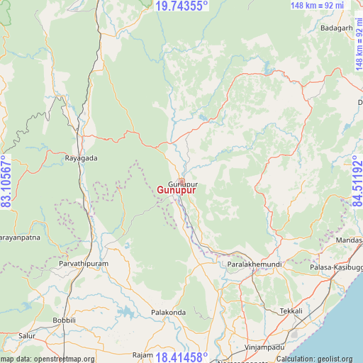
Gunupur GPS coordinates[2]
19° 4' 49.44" North, 83° 48' 31.644" East
| Map corner | latitude | longitude |
|---|---|---|
| Upper-left | 19.74355°, | 83.10567° |
| Center: | 19.0804°, | 83.80879° |
| Lower-right: | 18.41458°, | 84.51192° |
| Map W x H: | 147.8×147.8 km | = 91.8×91.8mi |
| max Lat: | 34.9274° ⇑68.4% North |
| Gunupur: | 19.0804° |
| min Lat: | ⇓31.6% South 8.09008° |
| min Long | Gunupur | max Long |
| 68.82655° | 83.80879° | 96.81° |
| W 81.5%⇐ | ⇒18.5% E |
Elevation
Elevation of Gunupur is 87 m = 285 ft, and this is 208.6 m = 684 ft below average elevation for this country.
| Max E: |
3681 m = 12077 ft | 71.2% |
| Avg. | 295.6 m = 970 ft | |
| Gunupur | 87 m = 285 ft | |
Min E: |
1 m = 3 ft | 28.8% |
See also: India elevation on elevation.city.
Geographical zone
Gunupur is located in North Torrid zone (between Equator and Tropic of Cancer). Distance of this Northern Tropic circle is 484.4 km =301 mi to North.| Distance of | km | miles | from Gunupur |
|---|---|---|---|
| North Pole | 7885.5 | 4899.8 | to North |
| Arctic Circle | 5279.6 | 3280.6 | to North |
| Tropic Cancer | 484.4 | 301 | to North |
| Equator | 2121.5 | 1318.2 | to South |


Nearby cities:
15 places around Gunupur: (largest is in red/bold)
• Amudālavalasa
75.2 km =46.7 mi,  172°
172°
• Bobbili
73.6 km =45.7 mi,  220°
220°
• Chikitigarh
85.7 km =53.3 mi,  80°
80°
• Digapahandi
86.5 km =53.7 mi,  67°
67°
• Ganguvāda
56.3 km =35 mi,  144°
144°
• Gudāri
29.9 km =18.6 mi,  354°
354°
• Mandasa
72.7 km =45.2 mi,  108°
108°
• Narasannapeta
78.1 km =48.5 mi,  161°
161°
• Palāsa
71.9 km =44.7 mi,  118°
118°
• Parlākimidi
44.4 km =27.6 mi, 138°
• Pālkonda
53.3 km =33.1 mi,  186°
186°
• Pārvatipuram
52.1 km =32.4 mi,  230°
230°
• Rāzām
71.9 km =44.7 mi, 192°
• Sompeta
82.9 km =51.5 mi,  100°
100°
• Tekkali
69.3 km =43.1 mi, 139°
Sources, notices
• [Note1] Compared only with cities in India existing in our database
• [Src1] Map data: © OpenStreetMap contributors (CC-BY-SA)
• [Src2] Other city data from geonames.org with taken over terms of usage.
• [Src3] Geographical zone / Annual Mean Temperature by Robert A. Rohde @ Wikipedia
