Nizāmābād geodata
Nizāmābād (Uttar Pradesh) is a populated place; located in India in Asia/Kolkata (GMT+5.5) time zone. With population of 13,895 people, there are 2574 cities with bigger population in this country. Compared to other cities in India, 70.8% of cities are located further ↓South; 79.4% of cities are located further ←West and 71.5% of cities have higher elevation than Nizāmābād. Note1


Nizāmābād GPS coordinates[2]
26° 3' 10.62" North, 83° 3' 28.332" East
| Map corner | latitude | longitude |
|---|---|---|
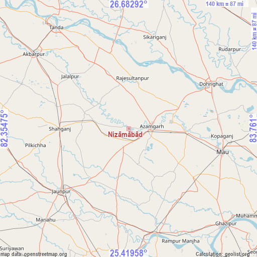
| Upper-left | 26.68292°, | 82.35475° |
| Center: | 26.05295°, | 83.05787° |
| Lower-right: | 25.41958°, | 83.761° |
| Map W x H: | 140.5×140.5 km | = 87.3×87.3mi |
| max Lat: | 34.9274° ⇑29.2% North |
| Nizāmābād: | 26.05295° |
| min Lat: | ⇓70.8% South 8.09008° |
| min Long | Nizāmābād | max Long |
| 68.82655° | 83.05787° | 96.81° |
| W 79.4%⇐ | ⇒20.6% E |
Elevation
Elevation of Nizāmābād is 86 m = 282 ft, and this is 209.6 m = 688 ft below average elevation for this country.
| Max E: |
3681 m = 12077 ft | 71.5% |
| Avg. | 295.6 m = 970 ft | |
| Nizāmābād | 86 m = 282 ft | |
Min E: |
1 m = 3 ft | 28.5% |
See also: India elevation on elevation.city.
Geographical zone
Nizāmābād is located in North temperate zone (between Tropic of Cancer and the Arctic Circle). Distance of this Northern Tropic circle is 290.9 km =180.8 mi to South.| Distance of | km | miles | from Nizāmābād |
|---|---|---|---|
| North Pole | 7110.2 | 4418.1 | to North |
| Arctic Circle | 4504.4 | 2798.9 | to North |
| Tropic Cancer | 290.9 | 180.8 | to South |
| Equator | 2896.8 | 1800 | to South |


Nearby cities:
15 places around Nizāmābād: (largest is in red/bold)
• Atraulia
33.1 km =20.6 mi,  340°
340°
• Azamgarh
12.7 km =7.9 mi,  82°
82°
• Bilariāganj
23.2 km =14.4 mi,  46°
46°
• Bishunpur Urf Mahārājganj
23.7 km =14.7 mi,  14°
14°
• Ghosī
48.4 km =30.1 mi, 83°
• Gola Bāzār
43.8 km =27.2 mi,  42°
42°
• Jainpur
29.9 km =18.6 mi,  67°
67°
• Jalālpur
42.9 km =26.7 mi,  312°
312°
• Kirākat
48.3 km =30 mi,  197°
197°
• Mehnagar
20.2 km =12.6 mi,  163°
163°
• Mubārakpur
23.6 km =14.7 mi, 80°
• Muhammadābād
32.4 km =20.1 mi,  93°
93°
• Phūlpur
18.4 km =11.4 mi,  278°
278°
• Sarāi Mīr
14.2 km =8.8 mi,  258°
258°
• Shāhganj
37.3 km =23.2 mi,  269°
269°
Sources, notices
• [Note1] Compared only with cities in India existing in our database
• [Src1] Map data: © OpenStreetMap contributors (CC-BY-SA)
• [Src2] Other city data from geonames.org with taken over terms of usage.
• [Src3] Geographical zone / Annual Mean Temperature by Robert A. Rohde @ Wikipedia
