Jalālpur geodata
Jalālpur (Uttar Pradesh) is a populated place; located in India in Asia/Kolkata (GMT+5.5) time zone. With population of 31,388 people, there are 1382 cities with bigger population in this country. Compared to other cities in India, 73.1% of cities are located further ↓South; 78.7% of cities are located further ←West and 70.5% of cities have higher elevation than Jalālpur. Note1


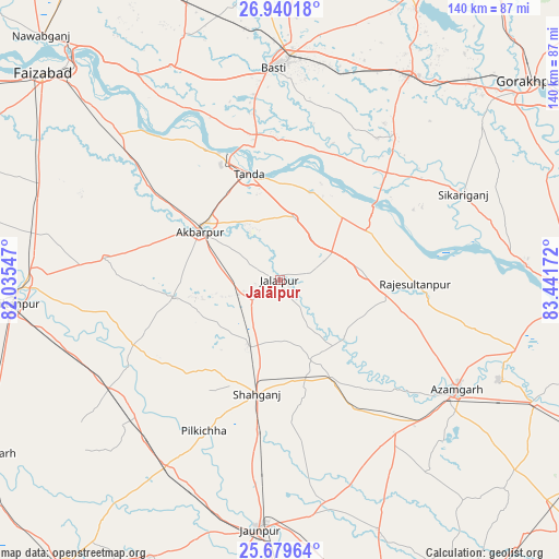
Jalālpur GPS coordinates[2]
26° 18' 41.832" North, 82° 44' 18.924" East
| Map corner | latitude | longitude |
|---|---|---|
| Upper-left | 26.94018°, | 82.03547° |
| Center: | 26.31162°, | 82.73859° |
| Lower-right: | 25.67964°, | 83.44172° |
| Map W x H: | 140.2×140.2 km | = 87.1×87.1mi |
| max Lat: | 34.9274° ⇑26.9% North |
| Jalālpur: | 26.31162° |
| min Lat: | ⇓73.1% South 8.09008° |
| min Long | Jalālpur | max Long |
| 68.82655° | 82.73859° | 96.81° |
| W 78.7%⇐ | ⇒21.3% E |
Elevation
Elevation of Jalālpur is 90 m = 295 ft, and this is 205.6 m = 675 ft below average elevation for this country.
| Max E: |
3681 m = 12077 ft | 70.5% |
| Avg. | 295.6 m = 970 ft | |
| Jalālpur | 90 m = 295 ft | |
Min E: |
1 m = 3 ft | 29.5% |
See also: India elevation on elevation.city.
Geographical zone
Jalālpur is located in North temperate zone (between Tropic of Cancer and the Arctic Circle). Distance of this Northern Tropic circle is 319.7 km =198.7 mi to South.| Distance of | km | miles | from Jalālpur |
|---|---|---|---|
| North Pole | 7081.5 | 4400.2 | to North |
| Arctic Circle | 4475.6 | 2781 | to North |
| Tropic Cancer | 319.7 | 198.7 | to South |
| Equator | 2925.6 | 1817.9 | to South |


Nearby cities:
15 places around Jalālpur: (largest is in red/bold)
• Akbarpur
24.2 km =15 mi,  302°
302°
• Atraulia
20.9 km =13 mi,  83°
83°
• Azamgarh
52 km =32.3 mi,  121°
121°
• Bastī
53 km =32.9 mi,  357°
357°
• Bilariāganj
50.4 km =31.3 mi,  104°
104°
• Bishunpur Urf Mahārājganj
38.1 km =23.7 mi, 98°
• Dostpur
27 km =16.8 mi,  261°
261°
• Goshāinganj
45.8 km =28.5 mi,  309°
309°
• Haraiya
60.2 km =37.4 mi,  333°
333°
• Kādīpur
40.1 km =24.9 mi,  246°
246°
• Nizāmābād
42.9 km =26.7 mi,  132°
132°
• Phūlpur
29.4 km =18.3 mi,  152°
152°
• Sarāi Mīr
36.4 km =22.6 mi, 150°
• Shāhganj
29.6 km =18.4 mi,  190°
190°
• Tāndā
27.6 km =17.1 mi,  343°
343°
Sources, notices
• [Note1] Compared only with cities in India existing in our database
• [Src1] Map data: © OpenStreetMap contributors (CC-BY-SA)
• [Src2] Other city data from geonames.org with taken over terms of usage.
• [Src3] Geographical zone / Annual Mean Temperature by Robert A. Rohde @ Wikipedia
