Gola Bāzār geodata
Gola Bāzār (Uttar Pradesh) is a populated place; located in India in Asia/Kolkata (GMT+5.5) time zone. With population of 10,936 people, there are 2839 cities with bigger population in this country. Compared to other cities in India, 73.4% of cities are located further ↓South; 80.4% of cities are located further ←West and 72.5% of cities have higher elevation than Gola Bāzār. Note1


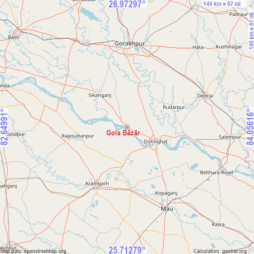
Gola Bāzār GPS coordinates[2]
26° 20' 40.56" North, 83° 21' 10.908" East
| Map corner | latitude | longitude |
|---|---|---|
| Upper-left | 26.97297°, | 82.64991° |
| Center: | 26.3446°, | 83.35303° |
| Lower-right: | 25.71279°, | 84.05616° |
| Map W x H: | 140.1×140.1 km | = 87.1×87.1mi |
| max Lat: | 34.9274° ⇑26.6% North |
| Gola Bāzār: | 26.3446° |
| min Lat: | ⇓73.4% South 8.09008° |
| min Long | Gola Bāzār | max Long |
| 68.82655° | 83.35303° | 96.81° |
| W 80.4%⇐ | ⇒19.6% E |
Elevation
Elevation of Gola Bāzār is 82 m = 269 ft, and this is 213.6 m = 701 ft below average elevation for this country.
| Max E: |
3681 m = 12077 ft | 72.5% |
| Avg. | 295.6 m = 970 ft | |
| Gola Bāzār | 82 m = 269 ft | |
Min E: |
1 m = 3 ft | 27.5% |
See also: India elevation on elevation.city.
Geographical zone
Gola Bāzār is located in North temperate zone (between Tropic of Cancer and the Arctic Circle). Distance of this Northern Tropic circle is 323.3 km =200.9 mi to South.| Distance of | km | miles | from Gola Bāzār |
|---|---|---|---|
| North Pole | 7077.8 | 4397.9 | to North |
| Arctic Circle | 4471.9 | 2778.7 | to North |
| Tropic Cancer | 323.3 | 200.9 | to South |
| Equator | 2929.2 | 1820.1 | to South |


Nearby cities:
15 places around Gola Bāzār: (largest is in red/bold)
• Atraulia
40.5 km =25.2 mi,  268°
268°
• Azamgarh
35.1 km =21.8 mi,  208°
208°
• Bilariāganj
20.8 km =12.9 mi,  217°
217°
• Bishunpur Urf Mahārājganj
25.4 km =15.8 mi,  248°
248°
• Bānsgāon
22.9 km =14.2 mi,  358°
358°
• Chillupār
16.8 km =10.4 mi,  114°
114°
• Deoria
45.9 km =28.5 mi,  67°
67°
• Dohrighāt
17.5 km =10.9 mi,  117°
117°
• Ghosī
32.4 km =20.1 mi,  145°
145°
• Jainpur
21.3 km =13.2 mi,  184°
184°
• Kopāganj
42 km =26.1 mi, 149°
• Mubārakpur
29.1 km =18.1 mi,  192°
192°
• Muhammadābād
34.6 km =21.5 mi, 175°
• Nizāmābād
43.8 km =27.2 mi, 222°
• Rūdarpur
28.2 km =17.5 mi, 66°
Sources, notices
• [Note1] Compared only with cities in India existing in our database
• [Src1] Map data: © OpenStreetMap contributors (CC-BY-SA)
• [Src2] Other city data from geonames.org with taken over terms of usage.
• [Src3] Geographical zone / Annual Mean Temperature by Robert A. Rohde @ Wikipedia
