Bishunpur Urf Mahārājganj geodata
Bishunpur Urf Mahārājganj (Uttar Pradesh) is a populated place; located in India in Asia/Kolkata (GMT+5.5) time zone. With population of 7,499 people, there are 3169 cities with bigger population in this country. Compared to other cities in India, 72.5% of cities are located further ↓South; 79.7% of cities are located further ←West and 71.2% of cities have higher elevation than Bishunpur Urf Mahārājganj. Note1
Current local time in Bishunpur Urf Mahārājganj:
11:20 AM, WednesdayDifference from your time zone: hours


Bishunpur Urf Mahārājganj GPS coordinates[2]
26° 15' 32.904" North, 83° 6' 59.148" East
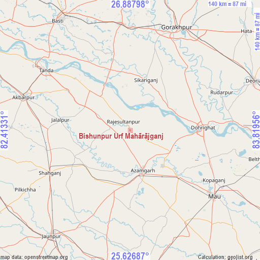
| Map corner | latitude | longitude |
|---|---|---|
| Upper-left | 26.88798°, | 82.41331° |
| Center: | 26.25914°, | 83.11643° |
| Lower-right: | 25.62687°, | 83.81956° |
| Map W x H: | 140.2×140.2 km | = 87.1×87.1mi |
| max Lat: | 34.9274° ⇑27.5% North |
| Bishunpur Urf Mahārājganj: | 26.25914° |
| min Lat: | ⇓72.5% South 8.09008° |
| min Long | Bishunpur Urf M | max Long |
| 68.82655° | 83.11643° | 96.81° |
| W 79.7%⇐ | ⇒20.3% E |
Elevation
Elevation of Bishunpur Urf Mahārājganj is 87 m = 285 ft, and this is 208.6 m = 684 ft below average elevation for this country.
| Max E: |
3681 m = 12077 ft | 71.2% |
| Avg. | 295.6 m = 970 ft | |
| Bishunpur Urf Mahārājganj | 87 m = 285 ft | |
Min E: |
1 m = 3 ft | 28.8% |
See also: India elevation on elevation.city.
Geographical zone
Bishunpur Urf Mahārājganj is located in North temperate zone (between Tropic of Cancer and the Arctic Circle). Distance of this Northern Tropic circle is 313.8 km =195 mi to South.| Distance of | km | miles | from Bishunpur Urf Mahārājganj |
|---|---|---|---|
| North Pole | 7087.3 | 4403.8 | to North |
| Arctic Circle | 4481.4 | 2784.6 | to North |
| Tropic Cancer | 313.8 | 195 | to South |
| Equator | 2919.7 | 1814.2 | to South |


Nearby cities:
15 places around Bishunpur Urf Mahārājganj: (largest is in red/bold)
• Atraulia
18.8 km =11.7 mi,  296°
296°
• Azamgarh
22.3 km =13.9 mi,  162°
162°
• Bilariāganj
13.1 km =8.1 mi,  122°
122°
• Bānsgāon
39.6 km =24.6 mi,  35°
35°
• Chillupār
39 km =24.2 mi,  86°
86°
• Dohrighāt
39.2 km =24.4 mi, 87°
• Gola Bāzār
25.4 km =15.8 mi,  68°
68°
• Jainpur
24.8 km =15.4 mi, 118°
• Jalālpur
38.1 km =23.7 mi,  278°
278°
• Mehnagar
42.3 km =26.3 mi,  180°
180°
• Mubārakpur
25.7 km =16 mi,  137°
137°
• Muhammadābād
36.4 km =22.6 mi,  133°
133°
• Nizāmābād
23.7 km =14.7 mi,  194°
194°
• Phūlpur
31.3 km =19.4 mi,  229°
229°
• Sarāi Mīr
32.5 km =20.2 mi,  217°
217°
Sources, notices
• [Note1] Compared only with cities in India existing in our database
• [Src1] Map data: © OpenStreetMap contributors (CC-BY-SA)
• [Src2] Other city data from geonames.org with taken over terms of usage.
• [Src3] Geographical zone / Annual Mean Temperature by Robert A. Rohde @ Wikipedia
