Bagasra geodata
Bagasra (Gujarat) is a populated place; located in India in Asia/Kolkata (GMT+5.5) time zone. With population of 32,944 people, there are 1321 cities with bigger population in this country. Compared to other cities in India, 59.1% of cities are located further ↑North; 98.6% of cities are located further →East and 59.1% of cities have higher elevation than Bagasra. Note1


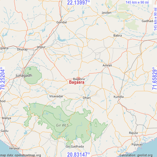
Bagasra GPS coordinates[2]
21° 29' 13.884" North, 70° 57' 18.576" East
| Map corner | latitude | longitude |
|---|---|---|
| Upper-left | 22.13997°, | 70.25204° |
| Center: | 21.48719°, | 70.95516° |
| Lower-right: | 20.83147°, | 71.65829° |
| Map W x H: | 145.5×145.5 km | = 90.4×90.4mi |
| max Lat: | 34.9274° ⇑59.1% North |
| Bagasra: | 21.48719° |
| min Lat: | ⇓40.9% South 8.09008° |
| min Long | Bagasra | max Long |
| 68.82655° | 70.95516° | 96.81° |
| W 1.4%⇐ | ⇒98.6% E |
Elevation
Elevation of Bagasra is 153 m = 502 ft, and this is 142.6 m = 468 ft below average elevation for this country.
| Max E: |
3681 m = 12077 ft | 59.1% |
| Avg. | 295.6 m = 970 ft | |
| Bagasra | 153 m = 502 ft | |
Min E: |
1 m = 3 ft | 40.9% |
See also: India elevation on elevation.city.
Geographical zone
Bagasra is located in North Torrid zone (between Equator and Tropic of Cancer). Distance of this Northern Tropic circle is 216.8 km =134.7 mi to North.| Distance of | km | miles | from Bagasra |
|---|---|---|---|
| North Pole | 7617.9 | 4733.5 | to North |
| Arctic Circle | 5012 | 3114.3 | to North |
| Tropic Cancer | 216.8 | 134.7 | to North |
| Equator | 2389.2 | 1484.6 | to South |


Nearby cities:
15 places around Bagasra: (largest is in red/bold)
• Amreli
29.3 km =18.2 mi,  64°
64°
• Bilkha
37 km =23 mi,  262°
262°
• Bābra
53.8 km =33.4 mi,  42°
42°
• Chalāla
23.4 km =14.5 mi,  111°
111°
• Dhorāji
59 km =36.7 mi,  297°
297°
• Dhāri
19.1 km =11.9 mi,  157°
157°
• Gondal
55 km =34.2 mi,  343°
343°
• Jetalsar
46.2 km =28.7 mi, 302°
• Jetpur
45.4 km =28.2 mi,  310°
310°
• Jūnāgadh
51.4 km =31.9 mi,  274°
274°
• Kundla
39.8 km =24.7 mi, 113°
• Lāthi
51.9 km =32.2 mi, 59°
• Mendarda
56.4 km =35 mi,  250°
250°
• Savarkundla
39.7 km =24.7 mi, 114°
• Vīsāvadar
26.9 km =16.7 mi,  232°
232°
Sources, notices
• [Note1] Compared only with cities in India existing in our database
• [Src1] Map data: © OpenStreetMap contributors (CC-BY-SA)
• [Src2] Other city data from geonames.org with taken over terms of usage.
• [Src3] Geographical zone / Annual Mean Temperature by Robert A. Rohde @ Wikipedia
